
…is a vote for where you want to walk or ride.
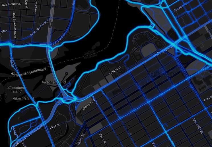
Screenshot from the Strava Global Heatmap, showing GPS traces from Strava users. Notice how some streets are no-go zones, and that there are a substantial number of people cycling on the Portage bridge west side sidewalk, bypassing the counter on the east side cycletrack. Metro will give us insights into how these usage patterns are established, and we’ll even see how they will change as new cycling infrastructure is built – Image: Strava
What is Strava?
The cities of Ottawa and Gatineau recently announced that they’ll purchase “Strava Metro” data to help inform decision-making for cycling and walking. So, what is Strava Metro, why should you care, and how can your trips be included in the dataset?
Strava is a free online fitness diary, where users record activities (running, cycling, skiing, etc.) using GPS devices and smartphones, then upload. The activities can be shared for a social/competitive aspect, or simply kept private for personal fitness tracking. The “Metro” part of this is that Strava will take all of those public activities, anonymize them, and then data analysts can have a really deep look at where, when, and how people are moving around cities on bike and on foot.
Athletic nature
This is a very powerful approach, but it also has some weaknesses, the key one being the highly athletic nature of the typical Strava user, and that most trips worth Stava-ing simply don’t represent all the short daily neighbourhood errand-running that is done on bikes and on foot. Kathryn Hunt put together an excellent discussion of these considerations over at the Incidental Cyclist blog, which is well worth reading.
Some data better than no data
But, in the belief that some data is better than no data, and that the best way to improve a biased sample is to sample more broadly, we encourage you to participate. This data will be used in decision-making about cycling and walking infrastructure. Every trip you take is a vote for where you want to go. The city will be able to learn how bike traffic flows at intersections, how usage patterns change in winter or darkness, which streets even the most enthsiastic Strava users refuse to use, how far out of our way some of us have to go to cross a river or a highway, the desire-lines that need to be made into official routes, how long pedestrians wind up waiting at intersections, and how far and how fast a typical active commuter will go. Of course, we here at Bike Ottawa plan to have our own look at the dataset, and use it in our advocacy efforts. If you’ve ever felt left out of all the bike counters because you live in Cumberland, Barrhaven, or Kanata, here’s your chance.
How to participate:
1) You must have a GPS device. Some of the more common ones include iPhone (iOS 7.0 and above: 4, 4s, 5, 5s, 5c, 6, 6+), Android (Most Android phones 4.0 and above), and of course fitness-specific and GPS devices, like Fitbit, Timex, TomTom and Garmin.
2) Sign up for a free Strava account at www.strava.com . If privacy is a concern, you can use an alias, control who can follow you, and set privacy zones around home, work, school, etc. As a fun option, you can also join the friendly BikeOttawa club (https://www.strava.com/clubs/ottbike), where you’ll be able to interact with like-minded folks and compare trips to the store or library. Joining the club isn’t required for your trip data to be included in the Metro dataset, though. Also entertaining is that you’ll see interesting alternative routes, discovered by other cyclists.
3) Start logging your trips. To be in the dataset, your trips must be public. Privacy zones are fine, though. To be sure they count as utility trips, rather than as fitness training, tag everything as a commute, and/or you can also use common keywords like “work”, “home”, “commute” in the title. This will help analysts filter the utility rides from the training rides.
4) Keep on tracking, and upload your trips from time to time. It will get to be a habit, and there are even some ways to make your device do the tracking automatically. Strava tells us that every ride and run (walk) collected from now through 2016 will be in the dataset.
Fun with data
And of course you can have your own fun with Strava. It doesn’t need to be all about further, faster, tougher, stronger. It might be interesting to know your total mileage for 2019, or get confirmation that you really did hit every.single.red.light. See how much 10 pounds of potatoes slows you down. Record some memories like celebrating making it up that steep hill towing a trailer, meeting up for a coffee with friends, or going on a group ride like our winter bike parade. We’ll see you out there, and maybe online, too. For more data, see also: Bike Data in Ottawa.