
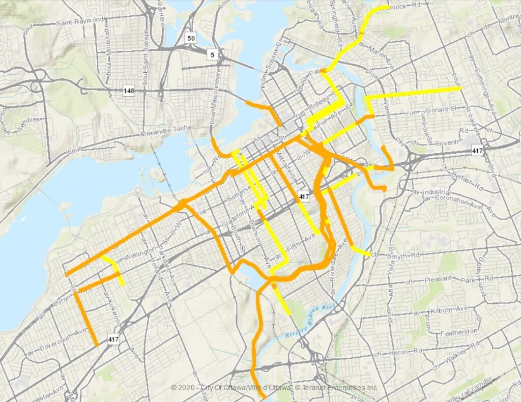
Ottawa’s Winter Cycling Network is made up of 50 kilometres of cycling tracks, pathways, and recommended routes that are maintained year-round for people riding bikes. Maintaining safe cycling infrastructure year-round is critical for encouraging a shift to sustainable transportation.
A map of the network is shown below.
The network has only expanded by 10 kilometres since it was created in 2015. Compare this to the 12,900 lane kilometres winter maintained for vehicles. There have been rumblings of a slow expansion of this seasonal transportation network, but does this coincide with the City of Ottawa’s declared climate emergency? We must remember that around 40% of GHG emissions come from transportation in Ottawa. The City’s Climate Change Master Plan states “Private action will range from individual choices (e.g., shifting from personal vehicles to transit or active transportation).” Bike Ottawa asks: does a slow expansion of alternatives to the automobile allow residents to make these individual choices? Research shows the key to keeping people on bicycles year-round is the quality of winter maintenance. We don’t have seasonal roads for cars and the City certainly felt the heat when winter maintenance of sidewalks sparked a comprehensive review of winter maintenance standards for all modes of transportation. So why are we so slow to give more residents the chance to get around on bicycles during our cooler months by expanding winter maintenance for bicycles?
Members of Bike Ottawa’s Data Working Group saw an opportunity to analyze city-wide data from the Strava Metro app to identify places where the Winter Cycling Network could be expanded quickly and easily, connecting more people to the existing network – low-hanging fruit for City staff.
Two criteria were used to select six new areas for expansion:
- places where people ride a lot in the fall but can’t in the winter because of lack of maintenance;
- places where people already ride a lot in the winter that could benefit from more predictable maintenance.
Areas where we saw high unmet needs include:
- Experimental Farm
- Pleasant Park Road
- Sawmill Creek Pathway
The graphic below shows a total decrease in the number of trips per segment between fall (September & October) and winter (January & February). The existing Winter Cycling Network is shown in green, and the 1600 segments with the largest drop from fall to winter are shown in purple to yellow, corresponding to a drop of at least 1250 trips or more (over two years).
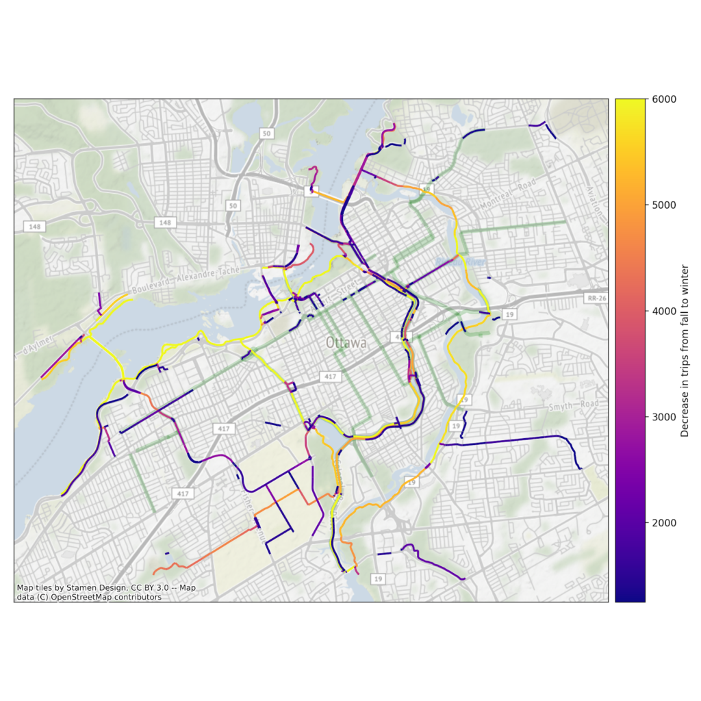
Total decrease in the number of trips per segment between fall (September & October) and winter (January & February).
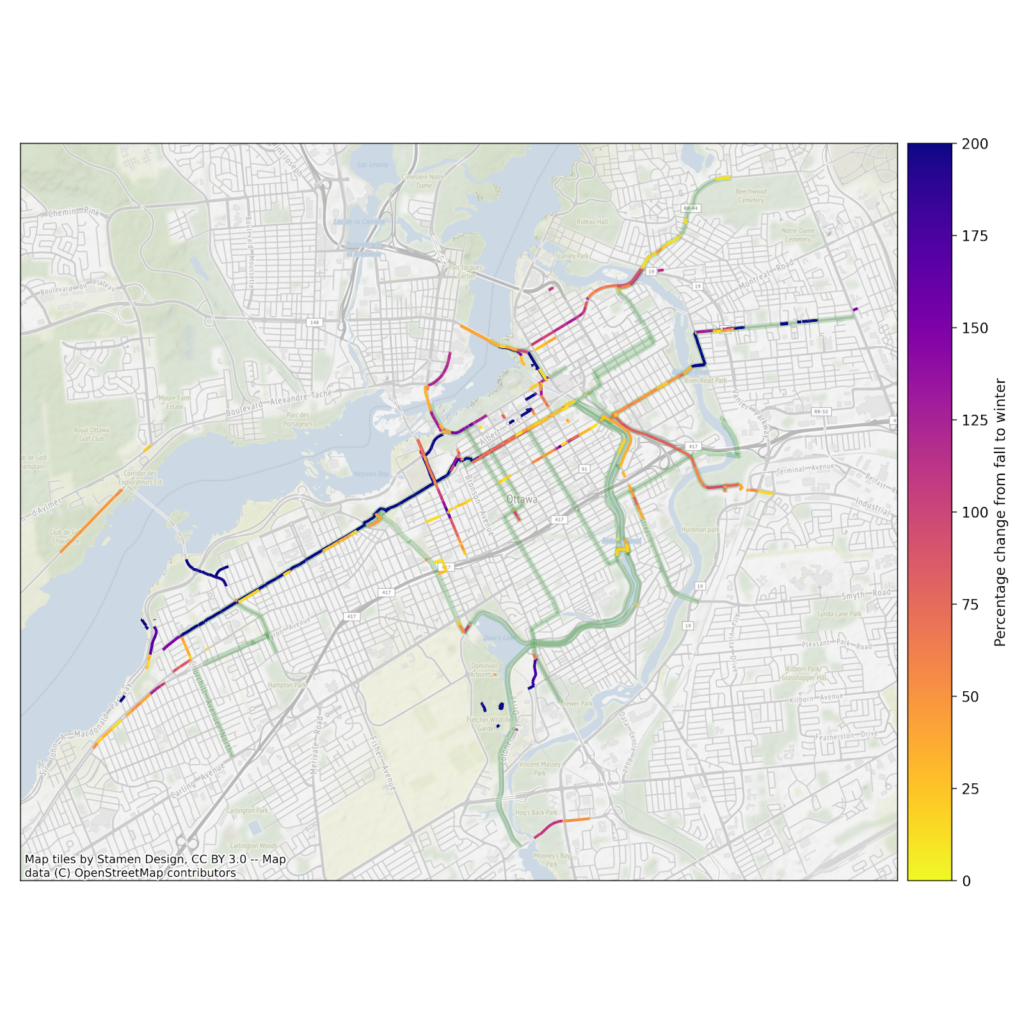
Areas with high winter usage that could benefit from winter maintenance for bicycles include:
- Hog’s Back Road and Brookfield Road
- Byron Avenue west of Churchill Avenue
- Booth Street
The graphic below shows the relative percentage increase in the number of Strava trips between fall and winter, normalized to the total number of trips in each season. The existing Winter Cycling Network is shown in green, and segments with at least 50 winter trips and a larger than 10% relative increase in ridership are shown in purple to yellow.
We also wanted to look and see how we could expand the network with a gender-focused lens.
Locations with a high percentage of trips made by women:
- Main Street north of Lees Avenue
- Sherwood Drive
- Carleton University (Campus Ave, Library Road, and path from Bronson)
The graphic below shows the number of trips made by women in January and February on segments with more than 5% female trips and more than 10 total trips. The existing Winter Cycling Network is shown in green.

The Winter Cycling Network Missing Links report has been forwarded to City staff, and as soon as the new council is sworn in, the report will be circulated to them.
For more information about Bike Ottawa’s work in supporting a year-round bicycle transportation network in Ottawa, please see our Annual Report on Cycling for 2021.