
The City is plunging forward with its reconstruction of Scott St. This is a two-stage process, with the first stage—from Churchill to Caroline—recently completed, and the second stage to start in spring 2023.
Written by William van Geest.
(For our comments on the entire project, see our earlier letter; see also the project page for the second phase).
This is an important project, as Scott St. is part of one of Ottawa’s crosstown bikeways.
The entire project has a lot to commend itself. Most importantly, the City is installing cycle tracks along the corridor and protected intersections at all signalized intersections. Cycle tracks, unlike the various alternatives that often pass as biking infrastructure, provide actual, physical protection for people biking. Similarly, protected intersections offer actual design solutions that help keep people safe at intersections, which are notorious conflict points. Together, these features take Ottawa’s network the next step toward being for all ages and all abilities.
While the fundamentals of the project are good, we have some concerns about some of the particulars. For one thing, we’re concerned about the space in the waiting areas in the protected intersections. Some of these In the recently reconstructed portion of Scott are so small that if you’re trying to cross to a corner where someone is already waiting, there won’t be enough space for you to come off the road fully.

This is especially problematic for people hauling trailers, such as those for transporting children. We think the City should not only revise the plans to avoid this problem, but also go back and correct the existing protected intersections with this dangerous flaw. (We identify several other problems with the constructed portion in the letter: see below!) This problem will only be exacerbated as more people bike this pathway, whether owing to generally safer infrastructure or to new developments going up in the area.
We also find the intersection at Carruthers to be…problematic.
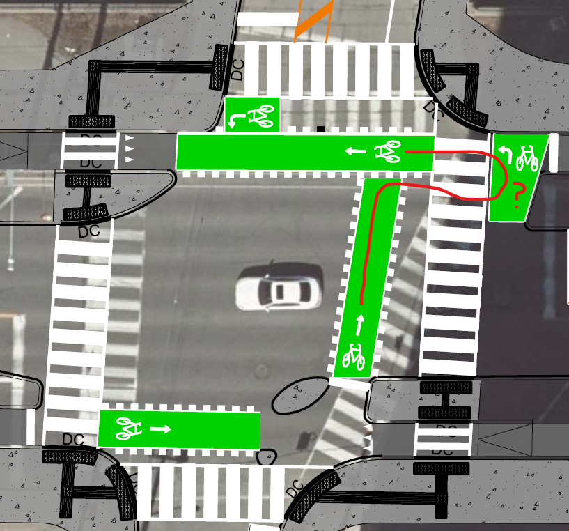
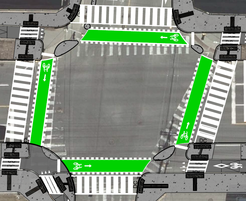
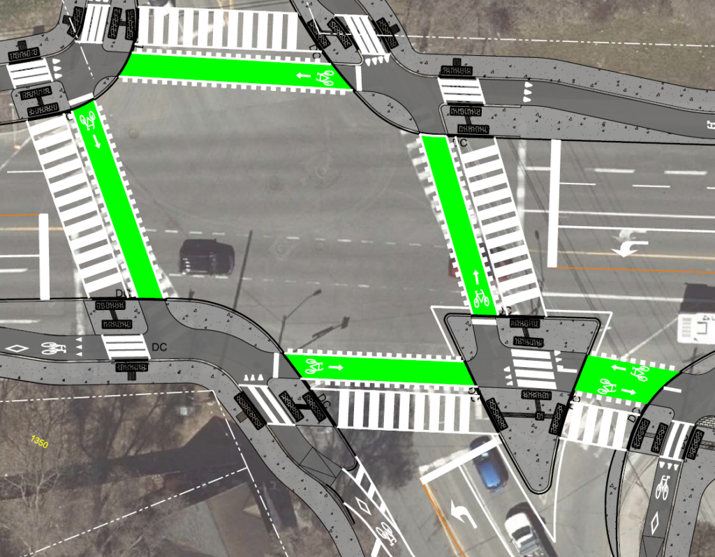
One important element of relatively intricate infrastructure—particularly when it’s new, as protected intersections are—is consistency: throw too many curveballs, and no one knows what they’re supposed to do. The intersection at Carruthers looks like the engineers got distracted halfway through and didn’t finish the job. Moreover, it looks like they’re calling for people coming from the south who intend to execute a two-stage left to bike against car traffic for a hot second (red line). Compare, by contrast, the intersection at Parkdale: much more intuitive (although obviously we’d love to see cycle tracks extending north and south from the intersection—a later project, hopefully).
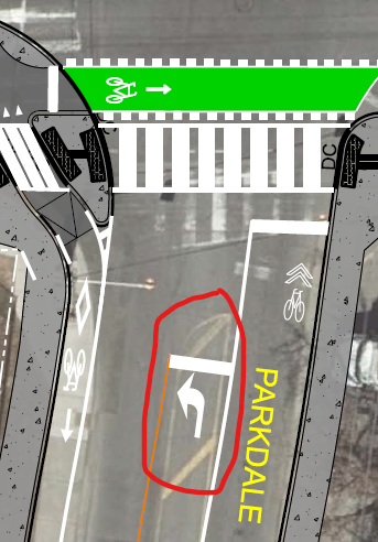
Still on the topic of intersections, we also find the City’s habit of adding turn lanes at intersections bewildering. Adding car lanes of course makes an intersection more dangerous for everyone: not only does the intersection take longer to cross—particularly for those with mobility challenges—but there are more streams of traffic for everyone to monitor, so collisions are far more likely. Of course, the only reason for adding car lanes is in the hopes of slightly reducing driving times. In our opinion, trading the safety of people walking, rolling, and biking for a few seconds of motorists’ time is a terrible deal. The City evidently thinks otherwise. In fact, they’ve somehow seen fit to add turn lanes even where there aren’t currently, such as on Parkdale south of Scott (circled in red).
Finally, the City has included a slip lane at the intersection of Bayview Station Road.
It’s nothing short of unconscionable that in 2022, the City of Ottawa is including slip lanes in designs, particularly in relatively urban areas like Scott; but here we are. Bike Ottawa opposes slip lanes on the strongest possible terms. Slip lanes prioritize the convenience of motorists over the physical well-being of everyone else. They have no place in our city.
We’ll leave the other details of our feedback for your perusal (see below). We hope you’ll keep your eye on this project as it evolves!
To: Kyle Delaney, Project Manager, Infrastructure Services, Robinson Consultants Inc.
Cc: Councillor Jeff Leiper – Ward 15 Kitchissippi
Via email: kyle.delaney@ottawa.ca, Jeff.Leiper@ottawa.ca
Date: August 23, 2022
Subject: Scott Street Protected Intersections – Parkdale Avenue to Bayview Station Road
Dear Mr. Delaney,
Bike Ottawa is a non-profit, volunteer-based organization that advocates for safe cycling infrastructure in Ottawa. We write to provide you with feedback concerning the plans for the Scott Street Protected Intersections – Parkdale Avenue to Bayview Station Road.
We are also pleased to see the City’s attention to vulnerable users, such as people walking and biking (28 July 2022 presentation)—although the City should not stop at “accommodating” them and instead prioritize them. By definition vulnerable users’ very safety is at threat, and every provision should be made to protect them. Moreover, modes like walking and biking are sustainable, and prioritizing these modes will help the City meet its climate goals and promote livability.
We are pleased to see the presence of cycle tracks and protected intersections in these plans. Cycle tracks affords actual, physical protection and represent an important step toward developing an all-ages, all-abilities biking network; and protected intersections mitigate much of the conflict that arises at conventional intersections. It is all the more important that these features be implemented on Scott Street, since it is part of one of Ottawa’s cross-town bikeways.
We are also pleased to see the reduction of vehicular lanes; such reductions have been shown to make roads safer for all users, including drivers.
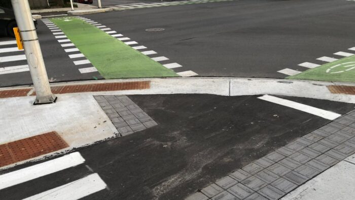
Finally, we are pleased that the City has begun installing raised, continuous crossings of minor streets—although we would urge that all crossings of driveways and minor streets be raised and continuous. Raised, continuous crossings signal to drivers that they are entering a space belonging to vulnerable road users and encourage them to yield right-of-way. Relatedly, curbs should be eliminated throughout the biking facilities, as they increase discomfort to people biking and even pose a barrier for children and people who use bikes as accessibility devices. We are disappointed that the City has unnecessarily maintained curbs almost throughout the recently reconstructed portion of Scott St (Figure 1a). Worse, some curbs are incomprehensibly high (Figure 1b), and even those apparently ground down will cause people biking significant discomfort, if not danger to both bike and rider (Figure 1c).
We have several general recommendations about the plans for this corridor:
- The cycle tracks should be at least 2.5 m, the largest width recommended in the Ontario Traffic Manual, Book 18, given that this is one of Ottawa’s cross-town bikeways. This width will allow for passing (less stressful for slower riders), more room for insecure riders and wider bicycles (e.g., cargo bikes and tricycles), provision for future volumes of people biking (build for the bike traffic we want!), and side-by-side riding (e.g., parents with young children).
- The cycle tracks should remain flat and above grade throughout the corridor, except where they enter major intersections. The cycle tracks added to the recently reconstructed portion of Scott St descend at not only every minor crossing, but in fact every driveway (Figure 2), creating a destabilizing “roller coaster” effect. There is no need for this design. If anything, a raised, continuous cycle track will encourage drivers to yield right-of-way to people using the cycle tracks.
- The cycle tracks should be designed in collaboration with winter maintenance staff to ensure all-season use. Biking infrastructure should be built to accommodate snow-clearing equipment, and streets should include appropriate space to store snow so that bike infrastructure remains clear.
- Relatedly, the cycle tracks should have adequate drainage, particularly to prevent ice build-up during winter months. This should not need mentioning, given that this corridor is part of the City’s winter-maintained cycling network, yet there are drainage problems in the recently reconstructed cycle tracks just west of the portion currently being planned (Figure 3).
- Trees should be added along the entire corridor. Apart from beautifying the corridor, trees would afford additional physical protection of people walking and biking. Trees also lower temperatures substantially, which has obvious health benefits during summer for people walking, biking, and rolling, and their presence near the roadway has been shown to slow down drivers, making the corridor safer for all users. Finally, trees absorb noise, which will improve the livability of the corridor. The current plans show ample space for trees, whether in the median or between car and biking facilities.
- Car lanes should be as narrow as possible, as narrower lanes have been shown to help slow motorists. Present car traffic speeds are often much faster than the posted 50km/h. Even relatively small speed reductions at these levels have been shown to reduce collisions and dramatically improve the outcomes for people biking and walking when collisions occur (Figure 4). Where car lanes must accommodate buses, narrowing solutions like pavement lanes with brick paver aprons should be considered (Figure 5).
- Medians should be considered along the entire corridor; not only do medians help slow car drivers, they can serve as a “refuge island” for people crossing the street, particularly those with limited mobility.
- Right turn on red for car drivers should be prohibited at all signalized intersections. Permitting right turns on red endangers all road users, and particularly with protected intersections frequently results in cars blocking crosswalks and cross-rides (Figure 6).
- All intersections should be raised, as in many intersections downtown. Raising an intersection encourages drivers to slow down on approach, making the intersection safer for all users.
- Current plans show tactile delineators separating walking and biking facilities in some locations. It is our understanding that for accessibility reasons, current best practice is half-height curbs.
- Waiting areas at these intersections for people biking should be enlarged. In many cases, these are only a bike length deep, and so even a single person waiting at the designated location will block people wishing to travel through the intersections. In some cases, it will be impossible to complete a crossing if there is someone waiting. This is particularly problematic for people pulling a trailer, such as those used to transport children, as the trailer would remain in the car lane until the person waiting cleared. This is precisely the situation in the recently reconstructed portion of Scott (Figures 7a and 7b).
- There are insufficient mid-block crossings along this corridor. People will attempt to cross Scott whether or not there is a crossing, and so a designated, safe (raised) place to do so should be provided. Two such locations are Merton and Garland.
- Some of the turn radii on minor streets and driveways are too large, which encourages drivers to take these turns at high speeds (e.g., Hinchey, Stirling, Pinhey, and Garland). These should be reduced.
With have several more-specific concerns regarding these plans:
- The slip lane at Bayview Station must be eliminated. Slip lanes encourage high car speeds and do so at the expense of the safety of all other road users. Bike Ottawa opposes slip lanes in the strongest possible terms.
- The connection to the Bayview LRT station is inadequate: specifically, there is no safe access from multi-use pathway that ends at Bayview Station Rd to Scott St. Failing to provide a safe connection southbound from this MUP will result in people biking southbound on the planned unidirectional northbound facility. We recommend extending the bidirectional biking facility at the SE corner of this intersection all the way to the MUP north of the LRT tracks. Eliminating the dedicated left-turn lane north of the intersection would not only provide ample space for this, but shorten the crossing for people walking, rolling, and biking across it.
- The superfluous car turning lanes at Parkdale and Scott should be eliminated.
- The right- and left-turn car lanes east of this intersection are truly excessive. Dedicated turn lanes offer only marginal benefits to car drivers—slightly reduced waiting times, in theory—but significantly increase danger for people crossing intersections, whether because of increased crossing distance or the additional lanes to monitor.
- There is no dedicated left-turn lane on Parkdale south of Scott in current conditions, and there is no justification for its addition: given the elimination of car lanes on Scott in these plans, car volumes should decrease. Moreover, this lane has been added at the expense of safe biking facilities: instead of cycle tracks there are sharrows, which have been shown to correlate with increased danger for people biking.
- Similarly, the dedicated turn lane on Parkdale north of Scott should be eliminated and the extra space given over to proper biking facilities around the corner.
- The westbound right-turn lane west of this intersection must be eliminated: because it extends the right-turn lane east of this intersection, there are essentially two westbound travel lanes through the intersection.
- Some physical barrier (e.g., bollards, large stones) should be installed at the Parkdale/Scott intersection to prevent motorists parking their vehicles along the raised curb, as currently occurs frequently (Figure 6).
- The design for the Carruthers protected intersection has several problems:
- There is no southbound cross-ride—despite the fact that there is a bike box for southbound travel. Proper cross-rides and waiting locations should be provided for every direction of travel in this intersection.
- “Eyebrows” that tighten turn radii for vehicles and help protect people walking and biking are mostly absent here.
- In general, designs should not deviate from standard protected-intersection design, as this can confuse road users, and intersections are high-conflict areas.
- Car parking on Carruthers south of Scott should be eliminated. On-street car parking takes up valuable public space, creates a risk of “dooring” for people biking, and interrupts sight-lines. There is no justification for car parking here, particularly given the narrowness of the right-of-way and the lack of adequate biking facilities.
- The planned cycle track seems to drop to road level between Stirling and Hilda. It should instead be above grade to provide people biking better visibility and maintain a consistent treatment throughout.
We thank you in advance for your careful consideration of our recommendations and ask for a reply to them. We would be glad to answer any questions you may have and would be pleased to work with you on any aspect of this project that relates to active transportation.
Sincerely,
William van Geest
Advocacy Working Group
Bike Ottawa
Scott Street Protected Intersections – Parkdale Avenue to Bayview Station Road
Bike Ottawa Feedback: Figures
Figure 1a: Cycle-track-interrupting curbs on recently reconstructed portion of Scott Street.
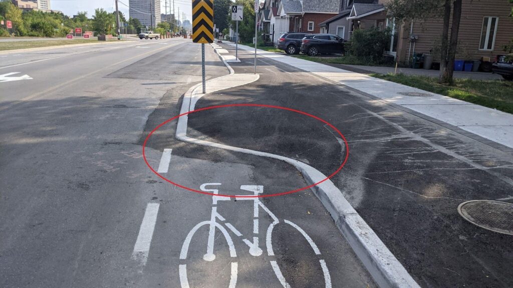
Figure 1b: Dangerously high “depressed” curb interrupting biking facility (Scott St., reconstructed 2022).
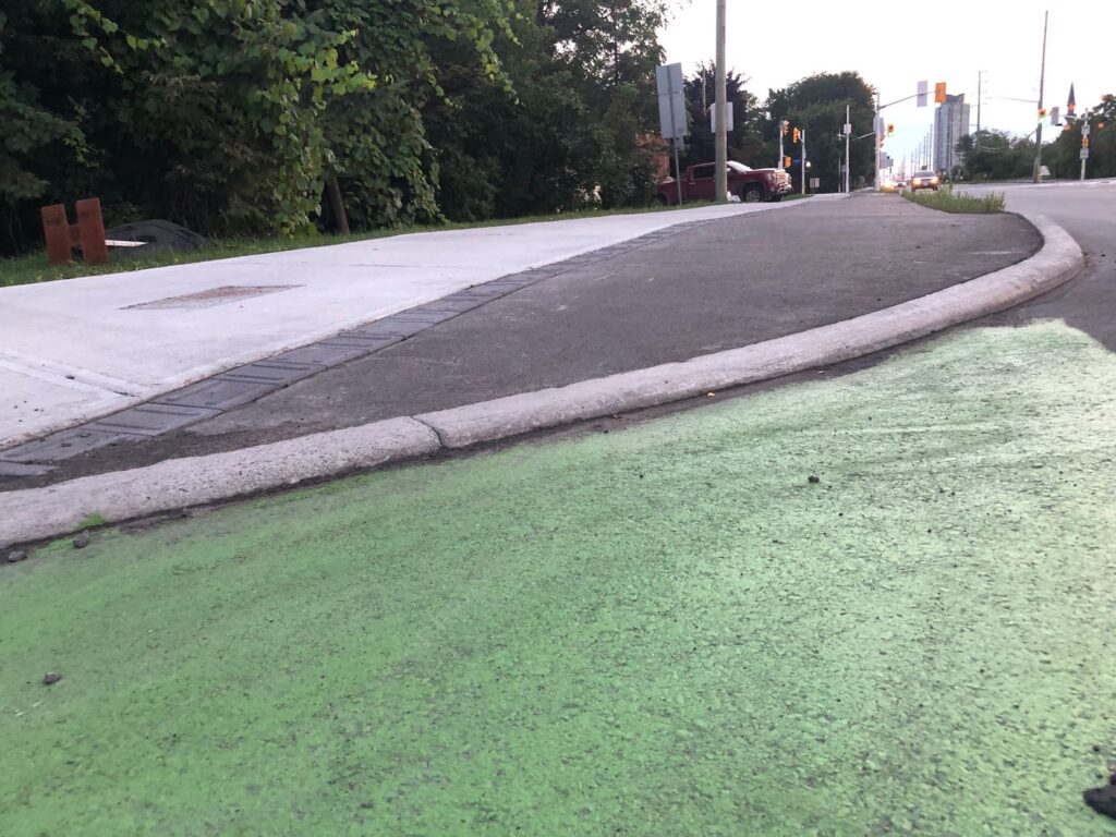
Figure 1c: Unacceptably steep “depressed” curb, even after grinding (Scott St., reconstructed 2022).
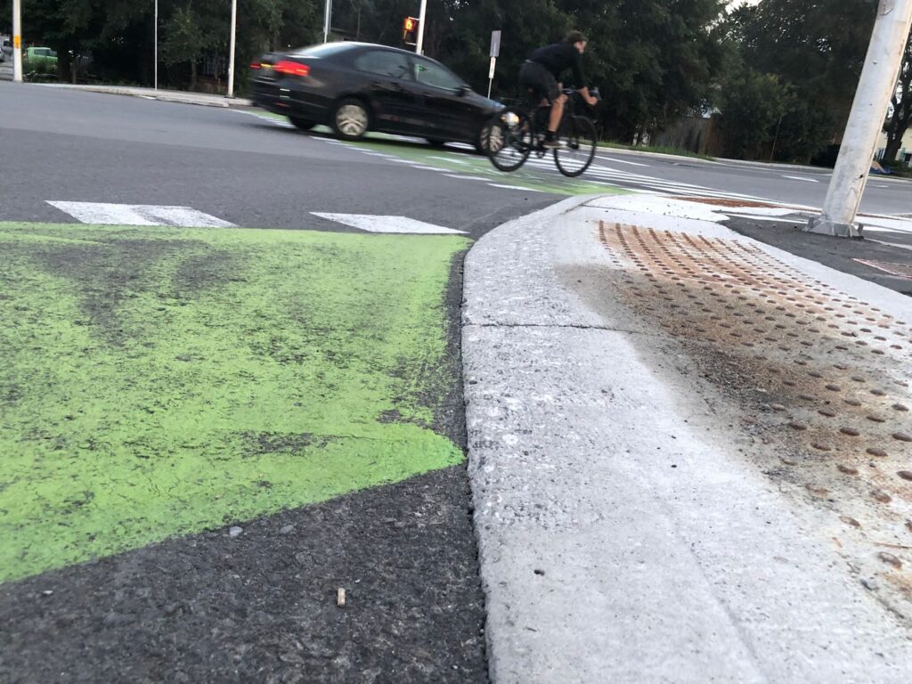
Figure 2: “Roller coaster” effect on Scott Street (reconstructed 2022).
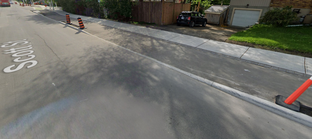
Figure 3: Drainage problems on recently reconstructed portion of Scott Street.
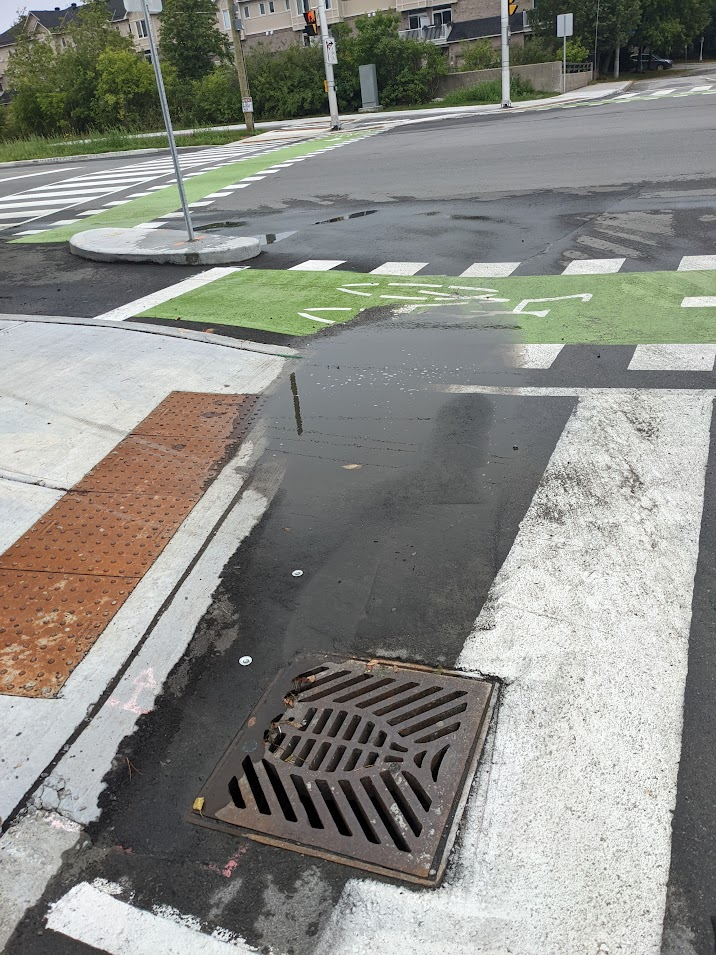
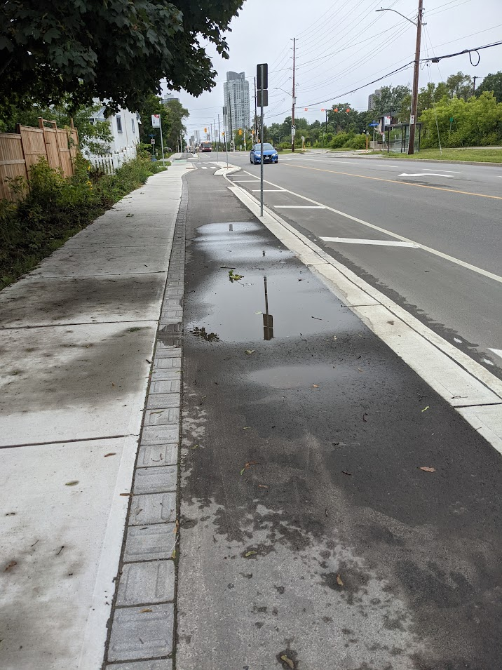
Figure 4: Chart of the relation between vehicle speed and the likelihood of death of a person struck while walking (from NACTO roundabout guide).
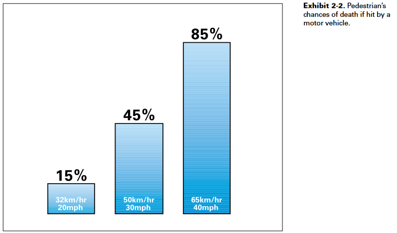
Figure 5: Example of lane-narrowing solution.
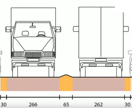
Figure 6: Vehicle blocking crosswalk and crossride while driver attempts a right turn on a red light at a protected intersection (Scott St, reconstructed 2022).
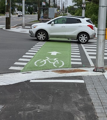
Figure 8: Inadequate waiting areas in protected intersections for people biking (Scott St, reconstructed 2022).
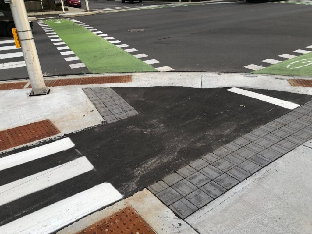
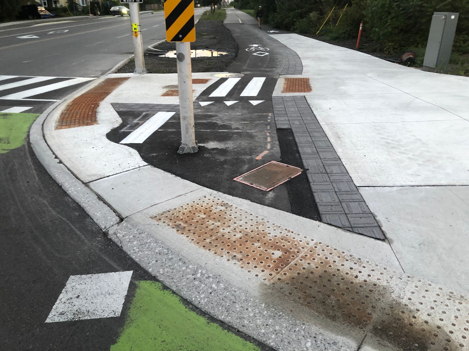
Figure 9: Cars parked at Quickie on Scott at Parkdale, blocking the biking facility.
*Title is a nod to NACTO’s Don’t Give Up at the Intersection.