
In May, the City of Ottawa released the Transportation Impact Assessment and Mobility Study for the new Civic Campus to be built at the Experimental Farm provides great detail about how hospital staff, patients and visitors will access the hospital and what infrastructure will be needed. Bike Ottawa volunteers have been poring over the study to see what has been proposed for the site, and how it will encourage sustainable transportation to reach the new campus.
Written by Barbara Greenberg, Érinn Cunningham, and William van Geest.
The plan acknowledges the importance of active transportation, but at every turn private motor vehicles are prioritized, casting doubt on how effective public transit and active transportation will be in bringing people to the campus. In fact, the slide deck presented by the hospital’s consultants does not mince words about the campus being unfriendly to walking and biking.
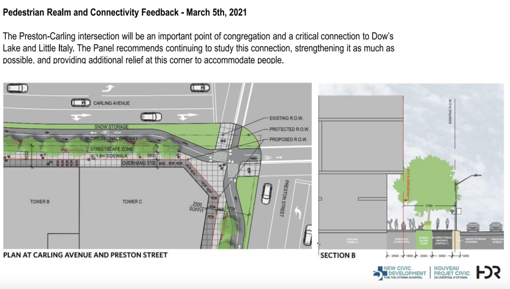
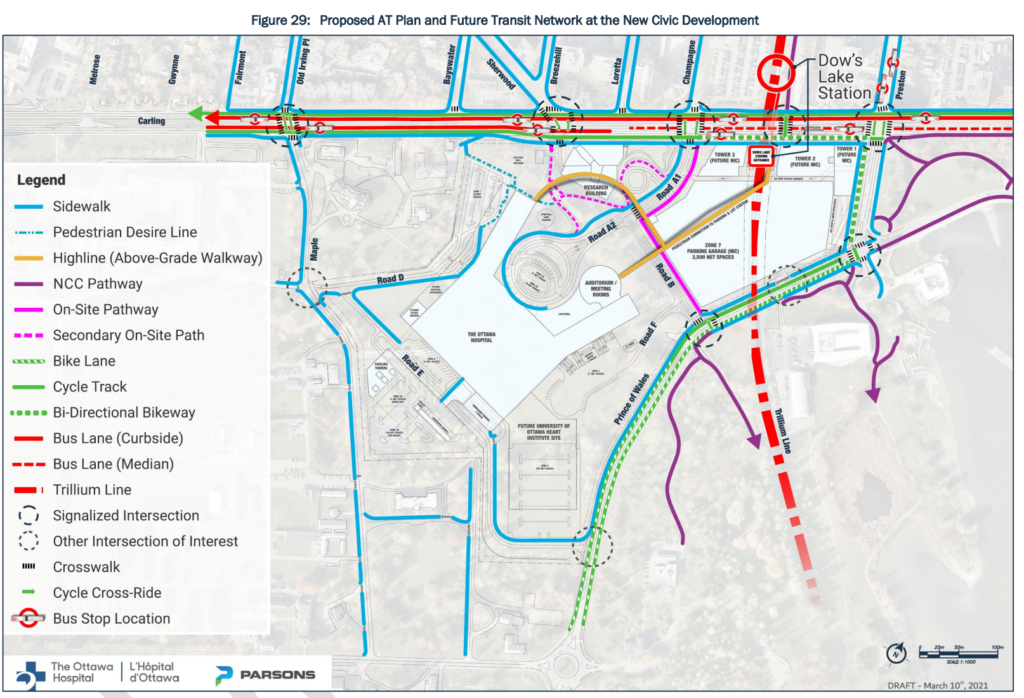
It’s no surprise, then, to find in the plans the hospital takes over city owned land, and removes an important existing active transportation route. What’s that, you ask? A portion of the existing Trillium multi-use pathway (MUP) from Carling Avenue to Prince of Wales Drive will be removed and “replaced” in order to make space for a parking garage. We’d love to see biking facilities on Preston Street, but not at the expense of a safer, low stress, Trillium MUP. With the removal of the Trillium MUP, people will be given two options. The first option will reroute people along Carling Ave to Preston Street, which is a higher-stress route– running adjacent to a bus route and motorized traffic, and through busy intersections, forcing people to navigate more conflict points, including Carling and Trillium, Carling and Preston, and the entrance to a very large and presumably much busier parking garage. Is this route designed for all ages and abilities to ride their bike?
The second replacement option is the “on-site path” to access Prince of Wales, which diverts people on bikes through a portion of the campus intended for calm pedestrian traffic and invites conflicts. At the very least this should be a segregated facility, but ideally the direct route should be preserved as it acts as more of a “bike highway”. Both replacements result in a poorer user experience.
If we want to become a city of active transportation, we need to add safe choices for routes, not remove them. This means building for the modal split we want going forward. If you want people to ride a bike to the hospital, then give them an abundance of safe route options, rather than making people who walk, roll, or bike “just go around.” Likewise, the main building and entrances are set so far away from the LRT station and the main streets themselves, forcing those who arrive by transit, rolling, walking, and biking, to travel the longest distances.
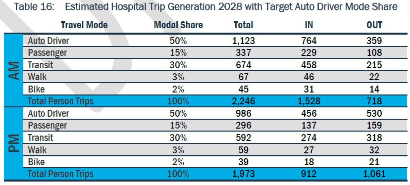
While we understand not everyone will be able to walk, roll, bike, or take transit to the hospital, many people will be able to make such a choice. But for people to make that choice, we need safe and convenient infrastructure that makes it easy to access the hospital. At present, the modal share estimates for the 2028 opening and the future growth of the hospital are egregious – just 3% for walking and 2% for biking. Even the 2013 Transportation Master Plan (soon to be replaced with the new Active Transportation Plan) calls for 10% walking and 5% biking modal share goals for 2031. The hospital will be located near well used multi-use pathways and an LRT station. When the City writes that its Official Plan is to have the “majority” of trips be made by sustainable transportation by 2046, why is the plan for the Civic Hospital aiming so incredibly low? Even the plan itself admits it will not be meeting the existing Transportation Master Plan targets because there is so much existing infrastructure devoted to private vehicles. The only thing that appears to meet the modal share targets are trucks.
Part of the blame lies at the feet of the City and parking minimums, and this is where things get tricky. The Hospital plan is designed to meet the outdated parking minimums required by the City of Ottawa, despite the proximity of rapid transit and active transportation links. But the hospital will be built and used after the New Official Plan is passed, and parking minimums near transit stations are to be reduced.
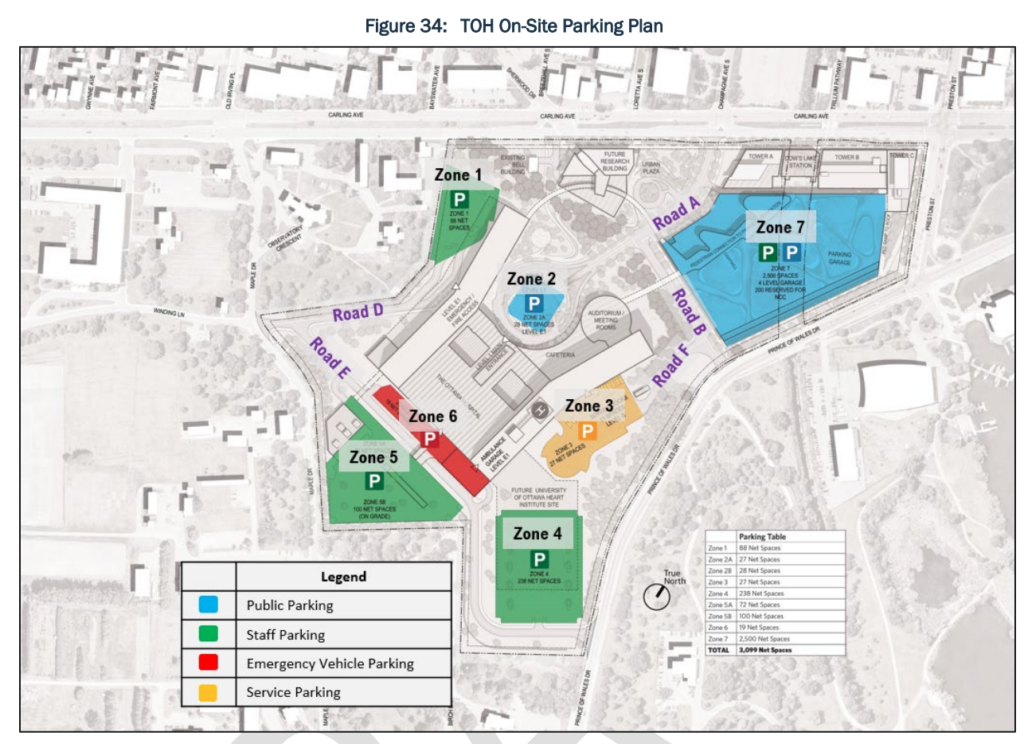
Meanwhile, the new Campus plan has put in 2,500 spaces of parking right across the street from the Carling LRT station. There’s a disconnect here in the planning process, the current guidelines, and upcoming changes in the new Official Plan. Better design is needed and the plans should be held to a higher standard than the previous guidelines currently being used for this site.
We believe that a hospital, of all places, must do better to encourage people to travel by sustainable modes. The new Campus will be served by LRT, bus rapid transit and – as the study itself acknowledges – benefits from strong connectivity to the current active transportation network. We believe the new Campus can and must do better to make sure that its transportation plans better align with the new Official Plan.
Below is the first letter Bike Ottawa has submitted in response to the proposed Civic Hospital plan.
To: Sean Moore, Planning, Infrastructure and Economic Development Department, City of Ottawa
CC: Councillor Jan Harder, Chair, Planning Committee, City of Ottawa
Councillor Glen Gower, Vice Chair, Planning Committee, City of Ottawa
Councillor Tim Tierney, Chair, Transportation Committee, City of Ottawa
Councillor Jeff Leiper, Kitchissippi Ward
Councillor Riley Brockington, River Ward
Via email: TOH@ottawa.ca, jan.harder@ottawa.ca, glen.gower@ottawa.ca, tim.tierney@ottawa.ca, jeff.leiper@ottawa.ca, riley.brockington@ottawa.ca
Date: June 18, 2021
Subject: Ottawa Hospital New Civic Campus Transportation Plan
Dear Mr. Moore,
Bike Ottawa is a non-profit, volunteer-based organization that advocates for safe bike infrastructure in Ottawa. We have reviewed the transportation study for the new Civic Hospital campus and would like to provide the following input. While this letter largely contains high-level observations about the transportation study, Bike Ottawa intends to submit more fulsome comments in the coming weeks to address the details of the transportation plan.
We are glad to see the inclusion of active transportation in the transportation plan, and that the plan acknowledges the importance of active transportation for ensuring smooth access to the hospital. Nevertheless, the plan in its current form prioritizes car travel in ways that disincentivize non-car travel and will ultimately make access to the hospital more difficult for all.
Some obvious examples of this prioritization of car travel are as follows:
- The parts of the plan pertaining to car travel are well-developed and detailed; those pertaining to biking, by contrast, are—by the plan’s own admission—underdeveloped (e.g., pp. 57, 63)
- Anyone who takes light-rail transit (LRT) to the hospital must walk further to get to the hospital than anyone who takes a car: the most remote spot in the parking structure is closer to the hospital’s main structure than the Dow’s Lake LRT station
- Certain aspects of the plan clearly prioritize vehicle movement over other transportation modes; for example, “future MMLOS for road segments and intersections did not meet minimum targets for pedestrian and cyclist performance,” but “The new Civic Development access intersections were all shown to operate well [for car traffic] in both future horizons” (p. 88)
- The plan’s language is car-centric: any reference to “traffic” implies car traffic and any reference to “parking” implies car parking, while the same terms for other modes are qualified by mention of that mode (“bike traffic,” etc.)
We also believe the modal share targets are inappropriate. The current modal share targets for 2028 are 3% for walking and 2% for bking. These goals fall significantly short of the modal share goals set out in the City of Ottawa’s Transportation Master Plan (2013), which call for targets of 10% for walking and 5% for biking by 2031 (p. 23). Moreover, the hospital is well-situated, connected to high-use transit lines and existing bike networks; there is no reason why these shares should not be similar to those of other urban areas in Ottawa, whose shares are much higher than the average just stated.
One of the serious flaws of these projections is that they are based on a modal share of 0% for active transportation at the existing Civic Hospital campus (p. 28), which is demonstrably inaccurate: many current employees, for example, bike to work. Another flaw is that estimates are based on the ITE Trip Generation Manual, which, as the plan acknowledges, are vehicle-centric, are based on United States travel patterns, and were completed decades ago (p. 26). While these figures may be “cost effective,” they produce inaccurate results that heavily privilege car travel.
The discussion of Transportation Demand Management (TDM) highlights many potentially helpful means of reducing vehicle reliance and promoting more sustainable modes like active transportation, such as:
- Establishing a full-time staff position for a TDM coordinator
- Policy-based financial incentives to using sustainable modes
- Provision of adequate bike parking, showering facilities, and lockers
- Educational programs for active transportation
- Partnership with local organizations devoted to sustainability
Nevertheless, these measures remain speculative. Given the importance of these measures for the new campus’s successful operation, they should be integrated with the main plan and should involve firm commitments.
Active Transportation Infrastructure
We are also concerned that the active transportation plan does not fully address the needs of people who are arriving to the campus by bike, or who are biking through the area to destinations beyond the campus:
- Bike Ottawa opposes removing the Trillium MUP between Carling and Prince of Wales in favour of a bikeway along Preston. The Trillium MUP functions as a bike highway, providing key connections to the Ottawa River pathway system, the Albert-Scott Crosstown Bikeway, planned facilities along Carling Avenue that will connect with The Glebe and neighbourhoods further west, the Rideau Canal MUP, the Arboretum MUP that connects to Carleton University, and Prince of Wales bike lanes that connect neighbourhoods to the south. As such, the Trillium MUP should be preserved with preference given to the current alignment, as it provides a low-stress, direct route to connect with the northern portion of the MUP. Realigning the MUP to follow Preston will also add considerable distance for pedestrians who use the Trillium MUP.
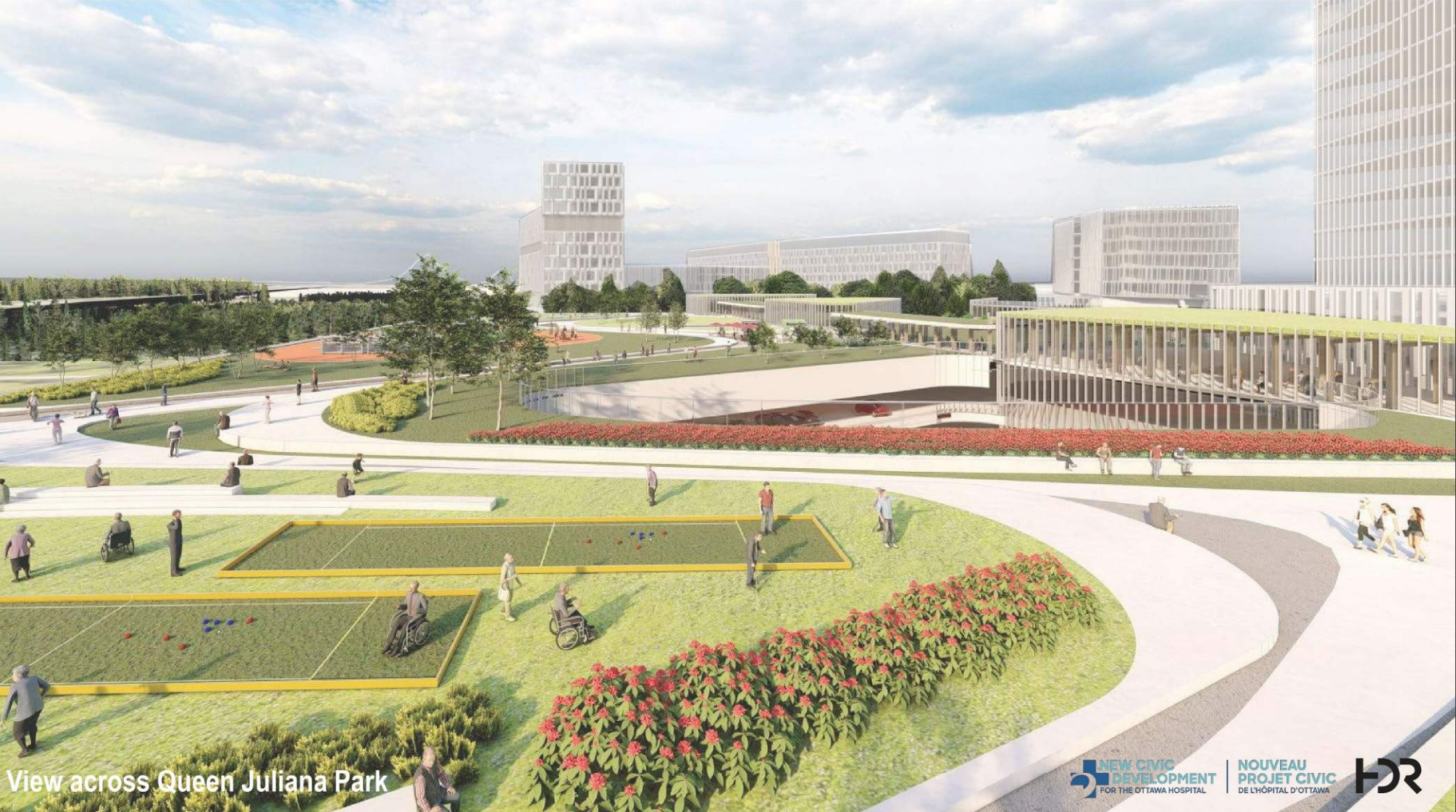
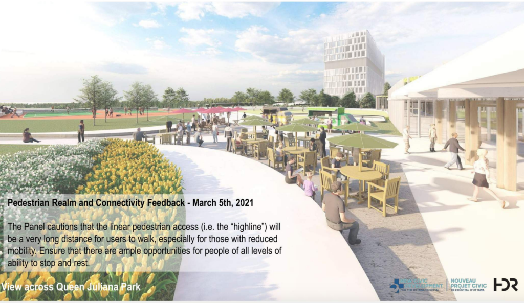
- Bike Ottawa recommends that the Queen Juliana Pathway be retained and designed in such a way that acknowledges its current role as an alternate north-south bike connection between the communities to the north and destinations to the south. Regardless of designation as a secondary path, the Queen Juliana pathway will continue to be viewed as a desirable bike route in the future.
- While the portion of the campus to the east of the escarpment includes active transportation links, we are concerned that the western portion features no bike infrastructure. In general, we find the road cross sections contemplated in the transportation plan to be overdesigned for local vehicular access. In order to provide a safer experience for people on bikes, we recommend building narrower streets with fewer lanes (maximum 3) designed for 30km/h operational speed. For streets designated for emergency services, such as Maple Lane, we recommend building segregated bike infrastructure to reduce the possibility of conflict between people on bikes and faster-moving ambulances.
- The proposal to upgrade the Prince of Wales bike lane on the north side to a cycle track is a welcome improvement, and we request that the sout- side bike lane receive similar treatment to improve safety in the area in light of increased traffic associated with the new campus. Ideally, cycle tracks should extend southwards to the traffic circle at the Experimental Farm.
- We are also pleased to see the proposed addition of a protected bikeway on Preston Street and crossrides at major intersections. Segregated bike infrastructure improves safety for all users on our streets and will make biking to the campus a more attractive option.
We thank you in advance for your consideration of our recommendations. Once again, we anticipate sending more detailed recommendations in the coming weeks. In the meantime, we are glad to discuss our feedback and any other issues that may arise at your convenience.
Sincerely,
Érinn Cunningham
President, Bike Ottawa
William van Geest
Advocacy Working Group Chair, Bike Ottawa
Note: A previous version contained a typo stating the parking garage near the LRT would contain 24,000 spaces. This has been amended to 2,500. (June 25, 20201).