

By 2046 it’s expected that Ottawa’s population will hit 1.4 million, and the new Official Plan is the legal document that will contain the City’s goals, objectives, and policies that will manage and guide this growth.
The Official Plan implements the City’s Strategic Plan in relations to land use, which impacts the economy, environment, and communities. The Official Plan also provides direction for many city plans, including the Infrastructure Master Plan, the Transportation Master Plan, and the Parks and Greenspace Master Plan.
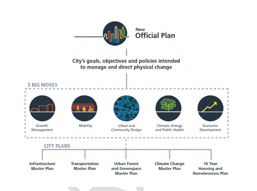
The Official Plan is centred around the “5 Big Moves” which includes Growth Management (“more growth by “regeneration” than by greenfield development); Mobility (“By 2046, the majority of trips in the City of Ottawa will be made by sustainable transportation”); Urban and Community Design (improve urban and community design, including priority areas, and policies that tailor to distinct neighbourhoods); Climate, Energy and Public Health (environmental, climate and health resiliency will be built into the framework of planning policy); Economic Development (“Embed economic development into the framework of planning policies”).
Bike Ottawa is encouraged to see the goal of having most trips be taken by sustainable transportation by 2046, and that discussions of mobility are at the core of the Official Plan. We believe that with some thoughtful consideration of how to make active transportation a more attractive option for people to move around all parts of the city, Ottawa can combat the climate crisis and develop in a way that makes it more of a space for people. We have studied the Official Plan Draft and submitted the following letter and addendum for consideration.
To: Alain Miguelez, Manager, Policy Planning, City of Ottawa
March 12, 2021
Dear Mr. Miguelez,
On behalf of Bike Ottawa, a safe cycling advocacy group, we would like to provide the following feedback on the draft Official Plan for the City of Ottawa.
We are encouraged to see that the Official Plan recognizes that the foundations for a livable city is encouraging sustainable transportation as a means for navigating 15-minute neighbourhoods, and sets the goal of the overwhelming majority of trips to be carried out in this way. Nonetheless, the ambitions of the Official Plan must be matched by concrete policies that will drive this transition through the Transportation Master Plan, including:
- Ensuring that all major infrastructure is built to prioritize the needs of the most vulnerable people on our streets year-round, namely people, walking, biking, and using mobility devices;
- Building active transportation infrastructure that links to rapid transit facilities within a 5km radius;
- Committing a portion of the annual budget to build and maintain active transportation infrastructure commensurate to the modal share the Official Plan envisions;
- Prioritizing ease of movement by active transportation, while discouraging motorized traffic through measures such as, eliminating parking minimums, filtered permeability, and congestion pricing; and,
- Enabling a shift towards cargo movement using cargo e-bikes and transshipment hubs to allow for safer, less-congested streetscapes in our city.
Bike Ottawa remains concerned that the City of Ottawa continues to encourage suburban sprawl that requires the expansion of the urban boundary. This type of development is uneconomical, wasteful and does not mesh with a strategy of prioritizing sustainable transportation, as it will inevitably lead to an increase in vehicle kilometres travelled. Given the City’s own declaration of a climate emergency, we believe there is a fundamental disconnect with the needless consumption of undeveloped land and addressing climate change.
While we applaud an increased focus on developing within the existing urban area, we would caution against the concept of urban regeneration, vs. intensification. Ottawa contains many successful neighbourhoods that do not require “regeneration” but instead require nurturing in order to thrive. While many auto-oriented parts of the city will require significant investment and intervention to shift them towards being places for people, we must also be mindful that for many, “urban regeneration” evokes the history of urban renewal that has also damaged, or even erased many successful neighbourhoods in our city, disproportionately impacting lower-income neighbourhoods where many Black, Indigenous and People of Colour communities can be found.
Bike Ottawa believes the draft Official Plan reflects a strong start from an aspirational stance, and looks forward to seeing more detailed implementation. Without the proper policies and ultimately, funding to implement the goals of the Official Plan, Ottawa will continue to develop in an unsustainable pattern that will squander the human, ecological and monetary capital we require to build a livable and sustainable city.
Sincerely,
Érinn Cunningham
President, Bike Ottawa
Cc: Mayor Watson, City Council
Bike Ottawa Feedback on the Official Plan Document
P.23 4) “viable transportation options” for small business growth should include cargo bikes, mobility lanes sufficiently wide for commercial cargo bikes, and passing.
P.27 1) “Compact and Connected City.” Walking and transit mentioned. Bicycles and other mobility devices have not. Use the term “Active Transportation.”
P.31 Policy Intent – “encourage development of healthy walkable 15-minute neighbourhoods”. Define “car-light” (means low speeds through design, traffic evaporation). Include bike parking and the city’s new bike parking strategy. Discourage car parking to better use street space.
P.35 Prioritizing winter maintenance for active transportation over cars is gender equity.
P.36 2) “improve mobility options for women” should not just include transit, but walking, cycling and other wheeled devices (use term “Active Transportation”). Discuss multi-modal trips.
P.37 “More” separated cycling facilities built? Language needs to be more concrete such as, “extensive network that consists of mobility highways to connect communities, main network, and then local slow streets. Wide, flat sidewalks. Pedestrian priority crossings everywhere. All well maintained year-round.
P.44 “the City shall prioritize sustainable transportation modes (notably transit, and access to stations or stops by cycling and walking) over the use of private vehicles.” Most trips are very short in distance. With 15-minute communities, active transportation networks need to be prioritized #1, not transit. This active transportation network will then link to transit for people to move in between nodes.
“To provide a transportation network that prioritizes sustainable modes over private vehicles, based on the opportunities for mode shifts presented by each Transect area context.” Should also include: prioritize sustainable modes over private vehicles through best practice safe road design for vulnerable road users.
P.48 No mention of cycling. Active transportation needs to be number #1, transit #2. Active transport is the cheapest form of infrastructure, healthiest for the community, and how people reach transit. It is the foundation of a transportation system.
P.49 “Increased access to sustainable modes of travel as well as the necessary infrastructure to support the electrification of private and public vehicles.” Change wording from “increased” to “prioritize.” “Increase” can mean a very slight increase. “Prioritize” has a very different meaning. Recognize that private vehicles, electric or not, still negatively impact our urban landscape. By not changing this wording, the City is contradicting gender equity priorities.
P.53 8) f) should not only read walking but year-round mobility network that includes bikes. Use the term “active transportation.”
P.53 3.5 5) “Industrial and logistic areas that are land extensive and need greater separation from neighbourhoods and requires access to a highway interchange.” Not entirely true. There should be logistic nodes closer to neighbourhoods to facilitate transfer to cargo bikes for more local deliveries (based on plans from courier companies and local businesses).
P.53 3.5 Does not mention how year-round mobility networks are essential for gender equity in terms of access to places of employment. Transit is mentioned, but people need to get to transit, and so an active transportation network needs to be prioritized.
P. 58 4.1 1) “Provide mobility options to safely and equitably navigate the city” Prioritize these mobility options.
4) “Support the shift towards sustainable modes of transportation” should instead read “prioritize sustainable modes of transportation in all planning.” The wording “shift” is non-commital.
P.58 “As a result, the City will take a more deliberate approach to the allocation of space for automobiles and prioritize the role of public transit and active transportation. The City is also committed to a Safe Systems Approach that reduces the frequency and severity of collisions for all road users” The City should be prioritizing active transportation, then public transport, then cars. Set a goal to eliminate road deaths and reduce injuries through design.
P.59 4.1.1 Should focus on the liveability of each street like Sweden’s 1-minute community.
P. 60 4.1.2 3) Priority should be given to active transportation users through design without signalization devices. Signalization devices should be used as a last resort. Where used, they should be configured to prioritize active transportation. Consider Dutch traffic controls that will change immediately on approach if no car traffic. One benefit is users not waiting in inclement weather conditions (whereas drivers are sitting comfortably in a car).
P.61 Paved shoulders cannot be maintained year-round for active transportation.
P.61 4.1.2 As the noise, and more so, air pollution has substantial negative impacts on those using active transportation, the more traffic, the more segregated the mobility pathways should be. Consider the network as a whole, ensuring connectivity to services, not necessarily building mobility pathways alongside major roads, but parallel and a slight distance away.
P.62 “ Policy 13 a.(ii), the City may consider proposals to provide shared cycling and motor vehicle street surfaces, when it is demonstrated that speeds and volumes are below a threshold for mixed travel modes.” This should only occur when speeds 20-30kph through design, very low traffic volumes, and little-to-no on-street parking.
P.63 22) Park and Rides should be eliminated. They demonstrate the lack of active transportation and encourage car use. Purchasing and operating a vehicle should not be required to access public transport. This is not equitable.
P.65 4.1.3 8) Reword – during construction, an active transportation network must be maintained and prioritized over car traffic on the same side of the construction project (as well as the other side of the road). The temporary mobility pathway must be safe, accessible for all users, all ages, well maintained year-round. Car traffic should be redirected to another route, if needed, to make this possible.
P.66 2) Eliminate parking minimums city-wide.
P.69 8 c) This needs to include personal vehicles that are above a specific size. Oversized pickup trucks, SUVs need to be regulated. They do not fit in urban environments—Montreal as an example where larger vehicles pay higher fees for parking on residential streets.
P.69 4.1.6 8) Movement of goods. The emergence of cargo bikes and small electric delivery vehicles. Plan for this with a well-connected active transportation network.
P.70 4.1.7 3) Rights of ways: Eliminate any future road widenings.
P.70 4.1.7 9) Use the term “active transportation” instead of “cyclists and pedestrians.”
P.71 4.2 Multi-unit dwellings (including community housing and retirement communities should all have a minimum number of bicycle parking spaces that are secure, protected from weather, accessible for all users, and accommodates all types of bicycles (cargo, recumbents, trikes, etc.). Coordinate with City’s new Bike Parking Strategy.
P.77 4.3 Large Scale Facilities: bicycle parking spaces that are secure, protected from weather, accessible for all users, and accommodates all types of bicycles (cargo, recumbents, trikes, etc.). On-site cycling facilities should connect with existing or planned city or NCC mobility networks, be well lit, wide, and designed for year-round use. Coordinate with City’s new Bike Parking Strategy.
P.80 4.4 Parks and Recreation Facilities: bicycle parking spaces that are secure, protected from weather, accessible for all users, and accommodates all types of bicycles (cargo, recumbents, trikes, etc.). On-site cycling facilities should connect with existing or planned city or NCC mobility networks, be well lit, wide, and designed for year-round use. Coordinate with City’s new Bike Parking Strategy.
P.92 Urban Design “What we want to achieve”: Include “streets that prioritize the movement and safety of vulnerable road users.”
P. 93 Table 5: “Pedestrian” needs to be replaced with “active transportation” with a focus on priority and safety for vulnerable road users.
P.95 4.6.2 Scenic routes: a desirable streetscape prioritizes active transportation and the safety of vulnerable road users
P.95 4.6.3 1) Public realm should always be enhanced. Reword to prioritize active transportation, not just pedestrians.
P.95 4.6.3 2) Should read “Prioritizing people over cars.” Reword to prioritize active transportation, not just pedestrians.
P. 96 4.6.3 4) Reword to prioritize active transportation, not just pedestrians.
P.97 4.6.4 Net Zero construction always.
P.98 4.6.5 3) Replace “pedestrian” with “active transportation. Replace “minimize conflicts” with prioritizing the safety and convenience of active transportation users over drivers. Bicycle parking spaces that are securely protected from weather, accessible for all users, and accommodates all types of bicycles (cargo, recumbents, trikes, etc.). Coordinate with City’s new Bike Parking Strategy.
P.98 4.6.5 4) Accessibility does not mean cars only. Accessibility needs to discuss everything outside cars as everyone driving starts and ends their trip outside a motor vehicle. Parking must also include bicycle parking spaces that are secure, protected from weather, accessible for all users, and accommodates all types of bicycles (cargo, recumbents, trikes, etc.). Coordinate with City’s new Bike Parking Strategy.
P.101 6) Change “Sustainable Modes of Transport” to active transportation for uniformity. Bicycle parking spaces that are secure, protected from weather, accessible for all users, and accommodates all types of bicycles (cargo, recumbents, trikes, etc.). They should be close to entrances and have wayfinding to find this parking easily. On-site cycling facilities should connect with existing or planned city or NCC mobility networks, be well lit, wide, and designed for year-round use. Consider businesses using cargo bikes to deliver or receive goods. (parking, pathway widths, connections. Coordinate with City’s new Bike Parking Strategy.
P114 2) Cycling distance should also be mentioned.
P.120 4.10 “What we want to achieve” All students should have access to safe active transportation networks that get them from home to school and back. Their movement has to be prioritized over cars. Bicycle parking spaces that are secure, protected from weather, accessible for all users, and accommodates all types of bicycles (cargo, recumbents, trikes, etc.) for students, parents and school staff. Coordinate with City’s new Bike Parking Strategy.
P.121 4.10.1 Reinforcing that active transportation needs to be designed for all ages, it must be reinforced that children might have underdeveloped capabilities for cycling and require to be safely segregated from cars at all times. Noise and air pollution are just as significant having detrimental health effects. Reduce vehicle movement around schools. Consider car-light streets near schools where only local traffic is permitted below speeds of 30kph through design (impossible to drive above 30kph). As always, these are year-round networks.
P.123 4.11 1) Retail Food Stores and 4) Licenced Daycares: Bicycle parking spaces that are secure, protected from weather, accessible for all users, and accommodates all types of bicycles (cargo, recumbents, trikes, etc.). They should be close to entrances and have wayfinding to find this parking easily. Coordinate with City’s new Bike Parking Strategy.
P.128 5.1 “What we want to achieve” should read active transportation.
P129 5.1.1. 2) Include active transportation.
P.130 5.1.2 Not every street in the Downtown Core should include cars. Many of the streets should prioritize active transportation for a healthier, safer, and more liveable environment. Even if every second street were car-light, this would vastly improve the public realm. Bicycle parking spaces that are securely protected from weather, accessible for all users, and accommodates all types of bicycles (cargo, recumbents, trikes, etc.). Coordinate with City’s new Bike Parking Strategy.
P.133 5.2 “What we want to achieve” should read active transportation.
P.135 5.2.2 Bicycle parking spaces that are secure, protected from weather, accessible for all users, and accommodates all types of bicycles (cargo, recumbents, trikes, etc.). They should be close to entrances and have wayfinding to find this parking quickly. On-site cycling facilities should connect with existing or planned city or NCC mobility networks, be well-lit, wide, and designed for year-round use. Consider businesses using cargo bikes to deliver or receive goods (parking, pathway widths, connections). Surface parking should never be prioritized over the safe movement of people. Coordinate with City’s new Bike Parking Strategy.
P.138 5.3 Introducing active transportation in these communities should not be a challenge. There is ample space for pathways, facilities and/or redesigning streets for people, not cars. These should be one of the most effortless environments to build active transportation as there is more space.
P.140 5.3.2 1) Eliminate future construction of Park and Rides. Instead, provide excellent active transportation facilities and bicycle parking spaces that are secure, protected from weather, accessible for all users, and accommodates all types of bicycles (cargo, recumbents, trikes, etc.). Coordinate with City’s new Bike Parking Strategy.
P.140 5.3.2 2) Arterials should become pleasant places for people – not highways. Reduce speeds drastically through design and always include active transportation well segregated and safe. All intersections have to prioritize people, not cars. People in these communities deserve enjoyable places to live too. Bicycle parking spaces that are securely protected from weather, accessible for all users, and accommodates all types of bicycles (cargo, recumbents, trikes, etc.). They should be close to entrances and have wayfinding to find this parking easily. Coordinate with the City’s new Bike Parking Strategy.
P.140 5.3.3 5) Active transportation – not pedestrian and cyclist network.
P144 5.4.3.1) b) Active transportation – not pedestrian, shortcuts.
P.145 5.4.4 Bicycle parking spaces that are secure, protected from weather, accessible for all users, and accommodates all types of bicycles (cargo, recumbents, trikes, etc.). They should be close to entrances and have wayfinding to find this parking easily. Coordinate with City’s new Bike Parking Strategy. Use “active transportation.”
P149 5.5.2 Replace “walking and cycling” with active transportation. Bicycle parking spaces that are securely protected from weather, accessible for all users, and accommodates all types of bicycles (cargo, recumbents, trikes, etc.). They should be close to entrances and have wayfinding to find this parking easily. Coordinate with City’s new Bike Parking Strategy.
P163 6.1.1 Not every street in Hubs needs to include cars. Many of the streets should prioritize active transportation for a healthier, safer, and more liveable environment. Use the term active transportation instead of walking and cycling. Bicycle parking spaces that are securely protected from weather, accessible for all users, and accommodates all types of bicycles (cargo, recumbents, trikes, etc.). This parking should not take up space from those walking or rolling. Coordinate with City’s new Bike Parking Strategy.
P.165 6.1.2 6) f) Should read active transportation, not just pedestrian accessibility.
P.167 6.2 Remove Gladstone Avenue west of Preston Street as a Major Corridor (Mainstreet). The number of schools and dense residential development conflicts greatly with the high levels of fast-moving car traffic, and related safety, noise and air pollution. This creates a very unhealthy environment for residents. Scott Street and Carling Avenue are adequate East/West alternatives. This should be local car movement only (along with busses and emergency services). Restricting car use along this stretch should not change this area evolving into a more mixed-use development.
P171 6.3.2 Active transportation should always be prioritized no matter what 15-minute community.
P.172 6.3.3 Change walking and cycling to active transportation
P.174 6.4.1 Strategic movement of goods. Plan for hubs to move goods by electric cargo bikes (as planned by courier companies in Canada). Plan for small businesses to do the same. Quebec recognizes this with the new small business e-cargo bike rebate program as of 2021. Remember, these are still people that need to get to work or purchase goods or services. Just because it is a more industrial area does not mean that we can’t have a pleasant environment for active transportation used to move goods by e-cargo bike. There could be lower-income manufacturing jobs in these areas where employees would greatly benefit from an equitable transportation network.
P.178 6.5.3 e) Language – active transportation network will be needed.
P. 180 6.6.2 Parliament and Confederation Boulevard need to be car-free space. Due to its national significance, this space should be turned over for people, instead of unpleasant car traffic.. This would be a space that visitors would remember when they return home as a wonderful, safe place to enjoy. Tour busses would have a stopover area in Centretown out of view of this important area.
P.182 6.6.3 Walkways and cycleways (mobility pathways) should be segregated from each other, have ample space for all age groups and various skill levels visitors, and commuters might be travelling at different speeds by bike—turn-off areas for visitors to stop.
Queen Elizabeth Drive should be made a pedestrian and cycling the only corridor to provide enough space and take advantage of the beautiful scenery year-round. The same should happen for parts of Colonel By Drive.
P.184 6.6.4 Byward Market needs to be car-free and car-light in other areas. It is too important an area to take away space from people for private vehicles. This entire area should feel safe for young to old to walk or cycle.
P.187 6.6.6 Landsdowne should be car-light with very restricted movement. This space needs to be for people.
P.189 6.6.8 3) a) Language – Kanata North needs to prioritize active transportation and then public transportation.
P.207 9.2.2 Rural area villages are great areas for local active transportation networks. Mobility highways should connect these villages with other communities.
P210 9.3.2 Active transportation to get people from villages to workplaces.
P.222 10.2.1 Major Collector roads should be redesignated to reduce the number of vehicles (great sources of noise and air pollution) in areas with schools. An example would be Gladstone Ave. between Preston and Parkdale. There are too many children and families being negatively impacted by non-local car and truck traffic. Noise and air pollution affect the health of residents.
Have not seen any mention of air pollution in this plan. There are sensor around Ottawa providing us with data telling us where there is poor air quality, and when. Reprioritize roads with schools for local traffic only to make neighbourhoods healthier and liveable. The busier the roadways with cars, the more segregation is needed between vehicles and active transportation.
P230. 11.1 3) a) Use the term “active transportation.”
P.241 “Air Pollution Impact Assessment” is missing. This should indicate whether the road network needs to be adjusted to protect residents’ health.
P.243 “Transportation Impact Assessment”: eliminate Level of Service for vehicles and implement for active transportation. Personal vehicles must always be secondary when planning transportation networks. Building a city that no longer prioritizes cars means that vehicles’ Level of Service will go down to encourage residents to leave their cars behind.
P.252 Suggest placing definitions at the beginning of this document. (Missing “Active Transportation,” “Mobility Pathway,” “15-minute neighbourhood.”)