
“Bank Street Active Transportation and Transit Priority Feasibility Study”. The name is a mouthful. And with such a title you’d expect this project would try turning this hostile thoroughfare into a street for people. Unfortunately so far it doesn’t live up to those expectations.
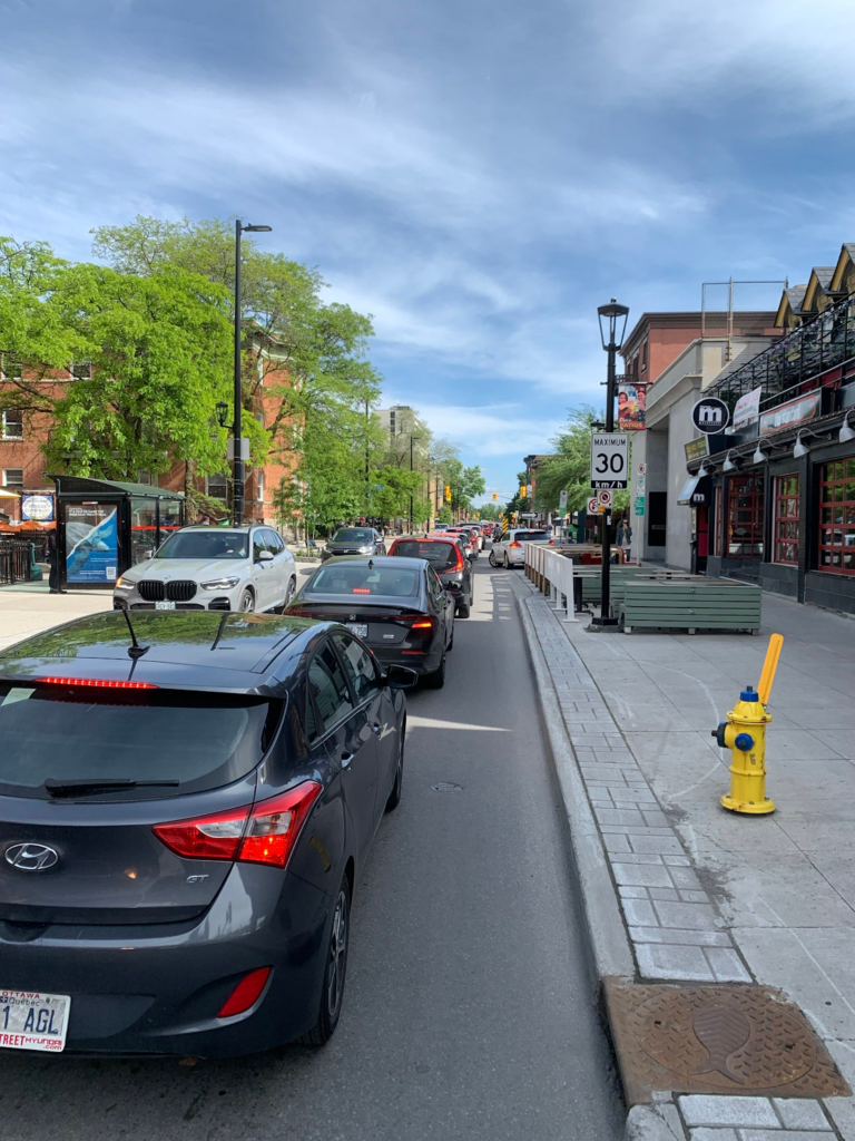
The city held a first virtual open house on the subject on 12 June, with a presentation focusing on four different options after a few slides focused on the current situation. And the current situation is: bad. The sidewalks are too narrow. Bike infrastructure is non-existent. Beg buttons for pedestrians display where the priority of the City is: car drivers and their cars. The street tries to be two things at once, and succeeds at neither: moving people quickly in and out of downtown, and being an attractive place for people. Spoiler alert: with car traffic prioritised above all else, this will never work. If people are still coming to Bank Street, it’s not thanks to car traffic, but despite it.
Back to the consultation, the process itself was underwhelming: most impactful options already off the table, virtual open house that is everything but open, comments limited to 255 characters in the online survey (which you can answer until 31 July 2024). For a deeper look, Neil Saravanamuttoo has you covered.

As for the actual content, it’s no better:
– The presentation looks at car traffic growth without even mentioning future pedestrian and bike traffic estimates.
– The complete on-street car parking removal is already off the table, even though it only accounts for 7% of the total supply in the neighbourhood.
– No mentions of the Official Plan and the Transportation Master Plan policies and commitments even though those documents should be the foundations and the touchstones of every project.
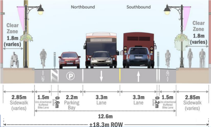
– Total lack of dedicated cycling facilities in 3 out of the 4 proposed options, and bad cycling facilities in the 4th option: lanes too narrow, bus stops interrupting bike lanes, winter maintenance ignored, etc.
Is this the best we can do?
You’ll find our full letter to the City below.
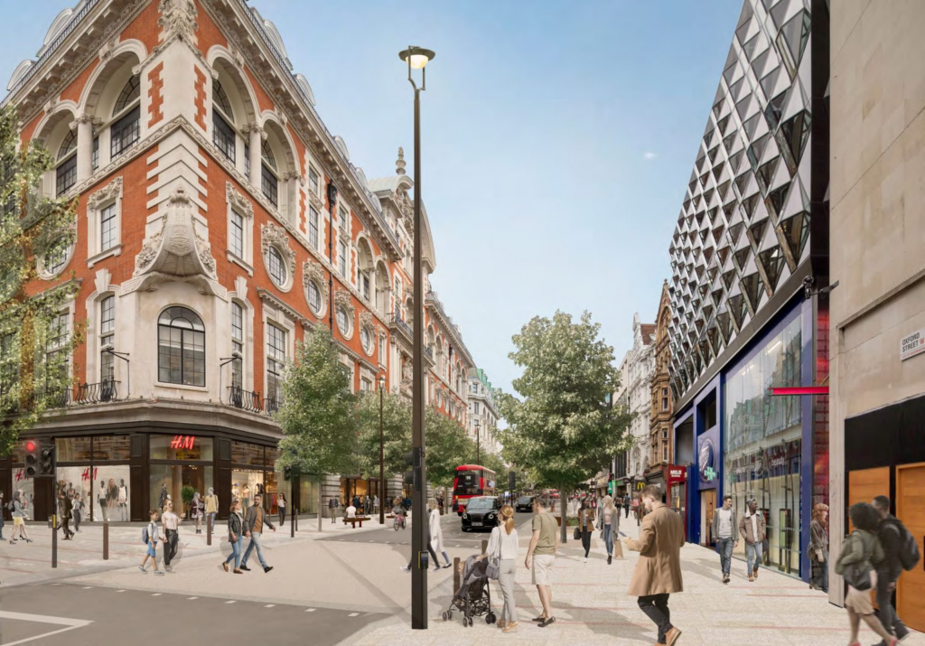
If we broaden our horizon a bit beyond the borders of the City, and look for examples of similar streets, Oxford Street in London comes to mind. Narrow right of way, high density of businesses and housing and high levels of traffic, there are many similarities. Well, the City of Westminster has made, and is planning to make, changes that would help solve the Bank Street conundrum: one car lane in each direction, no on-street car parking, no cars allowed between 7am and 7pm, only busses, taxis and bikes, wider and shorter pedestrian crossings, etc.
This project will shape Bank and the Glebe for decades, and yet the City wants to repeat the same mistakes as on Elgin. There’s no vision here, no boldness, no planning for the future. Only putting the wishes of people passing through by car before the needs of people actually living and going there. Matt Pinder is offering great leads on how to actually improve Bank Street in his latest blog post.
If you too aren’t pleased with the direction this project is headed, you can get involved: write to the project manager, to your councillor, to the media. Join others, make some noise. Go to the Critical Mass rides (second Saturday of each month, 10am at the War Museum, and last Friday of each month, 6pm at Confederation Park). Make your voice heard.
See you out there!
Read our letter to the city below:
To: Lise Guèvremont, Senior Project Manager, City of Ottawa, Transportation Planning
CC: Shawn Menard (Capital Ward), Ariel Troster (Somerset Ward)
Subject: Bank Street active transportation and transit priority feasibility study
Chère Madame Guèvremont,
We’re writing to you following the virtual open house regarding the Bank Street active transportation and transit priority feasibility study held on 12 June.
The changes to come will determine the shape of Bank Street and the Glebe for the foreseeable future. Bank Street is one of the city’s most iconic and central corridors, a huge part of the neighbourhood’s and the city’s personality. This is why we welcome this much needed study and deem it essential to bringing improvements to Bank Street. But although the project’s title itself sets high expectations, a more careful look reveals a chasm between the name and the actual content.
First off, the limitations of feedback in the online survey, as well as the format of the virtual open house, stymies public expression. Conversations on such an important issue should be held in the open if the City truly is interested in feedback from citizens. People were angry, and rightly so, and felt the whole affair to be performative. The tightly controlled Zoom meeting does not amount to public consultation.
As was noted in the presentation, the current condition on Bank Street is highly constrained, with a narrow right-of-way, a complete lack of bike infrastructure and sidewalks that can’t comfortably accommodate the current pedestrian demand. Bank Street in its current form is inhospitable to pedestrians (beg buttons, narrow sidewalks, noise and pollution from traffic, etc.) and cyclists (lack of infrastructure, heavy traffic).
The data presented shows that, despite the lack of infrastructure and the resulting feeling of unwelcomeness the street gives, a surprising amount of people dare bike on Bank. A modicum of cycling facilities exist in the area but, with Bank Street being both a destination and a corridor, proper separated cycling infrastructure is needed. The current numbers are but a foretaste of what they would be with safe infrastructure. Induced demand is a proven phenomenon that would create a virtuous circle, benefiting everyone: “build it and they will come”, as Montréal, Paris or London have all recently proven. Unfortunately the only projected growth discussed in the presentation is that of motor traffic. Nothing about pedestrians, transit or people on bikes, despite the fact that those numbers are bound to rise much faster with future densification and the betterment of our urban design. We’re rapidly approaching the limit for cars, but the limits for other modes are much further in the horizon. What the increase in traffic linked to the QED closure to cars mentioned in the presentation shows is that we need to prioritise the most efficient modes of
transportation. Cars are the opposite of that.
The exclusion by the project team of the possibility of completely removing on-street parking is also incomprehensible. Studies in multiple cities across the world, including in Canada, show that business owners routinely overestimate the share of their customers driving and underestimate the share of customers walking and biking, as well as how much they spend in their businesses. Without such a study showing that Bank Street is an outlier, the concerns about car parking should be considered irrelevant, especially since on-street parking is such a small proportion of total parking in the area, according to the City’s own data. It is the continuation of the current situation that should be excluded from the conversation—or supported by actual data. (What are the modal choices of customers of businesses along Bank Street? Where are the people driving on Bank going? Would people make different modal choices with better infrastructure and transit services? Etc.)
Discussed options should at the very least include the removal of the arterial and/or truck route designations, the much-needed widening of sidewalks and the removal of all on-street car parking. Otherwise, how could the City reach the 2031 modal share targets it set for itself in the 2013 Transportation Master Plan: 10% for walking, 8% for cycling within the Greenbelt, 26% for public transit?
Regarding specifically the bike facilities, several comments can be made:
- Physically protected infrastructure is an absolute must, given the high level of motorised traffic.
- Every intersection, not just signalled ones, and all crosswalks should be raised in order to slow down drivers and make it clear that they must yield to pedestrians and people on bikes.
- The growing demand for bike parking needs to be accommodated. Bike corrals offer an important density of parking spaces without encroaching on the already too limited space devoted to pedestrians. They also are a nice way of transitioning from car parking to more sustainable modes. If bump-outs are included in the final design, they would make good locations for such corrals.
Option D, the only option offering some cycling facilities, also raises specific problems:
- The bus stops interrupting the southbound bike lane will create conflicts and danger for people using the bike lane by forcing them into the general traffic lane, with cars coming upon them from behind.
- The proposed bike lanes are too narrow. The bike lanes will need to accommodate the growing numbers of cargo and delivery bikes, to say nothing about adapted bikes for those with accessibility needs. With a typical cargo trike being between 90cm and 1m, the proposed width of 1,5m leaves little to no room for manoeuvring and overtaking. The project should aim for 2m lanes where possible and never go under 1,8m. The Transportation Master Plan contains two policies directly addressing this issue: Policy 7-6 states the need to “plan for an increase in e-bikes, cargo bikes, se-scooters, and other users” and Policy 10-3 the need to “encourage and enable the use of smaller, human-powered, and electric vehicles for goods movement”. Option D completely ignores those imperatives from the TMP. We need to plan for the time when businesses realise the benefits of cargo bikes.
- Winter maintenance needs to be taken into account from the pre-design stage. It seems very unlikely that the sidewalks and the bike lanes could be made usable year-round without proper snow removal, given the lack of any buffer to store ploughed snow, which almost certainly means that bike facilities and sidewalks will be recipients of this snow.
As it is, the project doesn’t live up to its name, since priority is not given to transit and active transportation in any of the options: not one option improves the sidewalks, not one option gives priority to transit at all times and only one option somehow offers protection to people on bikes. However the project could be dramatically improved without the needless continuation of on-street car parking. This, coupled with the increase of people on bikes brought by proper infrastructure, would allow for a much better flow of buses, improving their attractiveness and ridership. This is also a matter of equity: according to the latest data from the Origin/Destination survey, the lowest-income downtown and inner core households use cars for less than half their trips, so prioritising that mode of transportation is putting them at a disadvantage.
Future designs should not be based on the city we have, but on the city we want and towards which the TMP and the Official Plan are pushing us: a safer, more livable and inclusive city, intent on reducing its carbon footprint and designed for people, not just cars.
We would welcome your feedback on this letter, and are available for further discussion.
Kind regards,
Guillaume Gaillard
Board member
Bike Ottawa