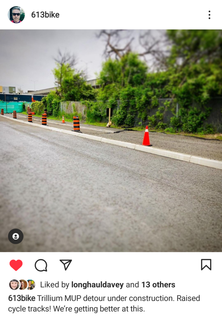
At the best of times in Ottawa, detours can receive some great thoughtful treatment – The Trillium path detour, for example, gave us a bi-directional bike lane for a large part of it, and held up well over the years it was in place.
It was hard fought, but well used, and made a huge difference keeping the same level of protection for people riding bikes, walking, and rolling along the Trillium pathway.
At the worst of times, and more generally speaking, construction detours are often a sign thrown up that says “Sidewalk closed” or “Cyclists dismount” or the dreaded “Bike lane closed”, and people are left to scramble at the last moment to get to where they need to go, while hoping drivers remember what it really means to “Share the Road”
In the case of LRT constructions, detours and detour requirements are actually laid out and given parameters are part of the work.
Section 3.3 of Part 6: Urban Design, Landscape Architecture and Connectivity Requirements:
Key points of note: All detours will:
“install a temporary granular pathway for closures less than 7 days in duration. Where the trail, sidewalk, pathway or MUP is required to be closed for longer than 7 days, DB Co shall provide an alternate route with a minimum of a paved asphalt surface for the duration of the closure. “
“provide an alternate route that minimizes any detours for the pedestrians and cyclists, and is a maximum of 20% additional length.”
Multiple subsequent closures of less than seven days, shall not be permitted, and an alternate route shall be provided and shall include: (i) Smooth paved surface to meet Universal Design requirements; (ii) Curb cuts as required to provide barrier-free routes from pathways and sidewalks to roadway crossings; (iii) A minimum width of 1.8m for sidewalks, as per COADS; (iv) A minimum width of 3m for MUP; (v) Positive drainage to ensure no ponding on the travelled route; and (vi) Temporary routes shall be lit to the same level as the original route.
On paper, not bad! In fact, at a Transportation Committee meeting not too long ago the City acknowledged they would look at these as a starting point for the new parameters for Construction and the Right of Way. (The City is currently working on these are Bike Ottawa is in discussions with staff regarding what can be done to make detours for those outside of vehicles safer and a priority, rather than an afterthought).
But I digress, we are looking at the detours of the LRT, which, in theory, have specific requirements. However, we’re seeing an emerging theme with some of the LRT detours in our work: That is, failure to comply with the parameters of the guidelines.
Where? Right now there are at least three ongoing issues: Holly Acres, Gladstone Ave, and Lincoln Fields.
Holly Acres Road
Holly Acres Road is one of the safest routes for traversing the major barrier that Highway 417 presents to people riding bikes in Ottawa. The corridor has had a multi-use pathway on each side of the roadway for almost 30 years, which makes it a very popular north-south choice to ride. In the inner suburbs of west Ottawa, only the Pinecrest Creek MUP offers a similar comfort level for biking across the Queensway.
The Stage 2 western extension of the LRT line will cross Holly Acres Road near Bayshore Station on its way to Moodie Drive. Kiewit Eurovia Vinci (KEV) is the construction arm of the Confederation Line Stage 2 contractor, East West Connectors.
To quote Dickens from A Tale of Two Cities, “It was the best of times, it was the worst of times…”. Along Holly Acres, we have been enduring the worst of times. KEV has been working on two major signalized intersections of Holly Acres Road that are impacted by the West Transitway being converted to rail:
The north intersection, where Holly Acres meets the Transitway and local bus access to Bayshore Station, plus the on-ramp for general traffic to Highway 417 West. This location is on the route of the new LRT line.
The south intersection, where traffic from the Highways 416/417 off-ramps is discharged onto Holly Acres. The work here is an indirect impact of the Stage 2 construction project.
Construction began on the north intersection in 2020. This intersection is directly affected because the train will cross Holly Acres on an “elevated guideway” (i.e. rail bridge) that had to be built adjacent to it. This intersection’s changes are only partly completed, as it provides key access points for KEV vehicles to reach the construction sites to both east and west of this point. The south intersection had to be modified only because the Transitway became unavailable between Bayshore and Pinecrest during conversion to rail. That closure forced many bus routes to skip Bayshore Station completely, supported by an additional lane for the highway off-ramp at the south intersection.
In all of this work, which continues to this writing, the MUPs have been adversely affected. The contractor seems wholly ignorant of active transportation users in the corridor. Despite numerous communications by Bike Ottawa to the Stage 2 Stakeholder Relations group, very little improvement in the contractor’s mode of operation has resulted.
Examples of the problems that we’ve raised:
- The crossride that traversed the north intersection for only a year following completion of West Transitway work was decommissioned as part of construction for Stage 2. This seems to have been just a cost-cutting measure by the contractor.
- The anchor point of a guy wire on a temporary signal pole was not properly protected, and a bicycle wheel went into its hole, causing a fall and broken bones to the person riding their bike.
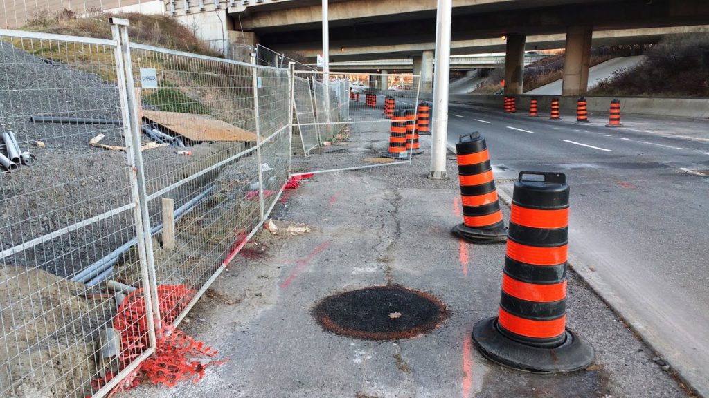
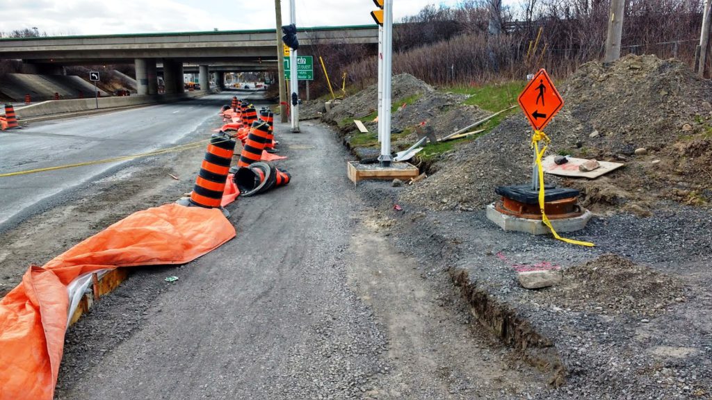
- The MUP on the west side of the road underneath Highway 417 was closed at the beginning of May of 2021, forcing everyone to bike on the east MUP through most of last year. However, the latter MUP was already being compromised in its width by construction fencing around the new rail bridge abutment, by casually stored construction warning barrels and signs when they weren’t being used for blocking off a road lane, and by pavement cuts and degraded maintenance-hole covers on the MUP surface.
- With construction on the south intersection having begun in late 2021 and intensifying this spring, the west MUP portion remains closed. Even more of the east MUP is made miserable, being narrowed to 1.5 metres at the worst. Poles to comply with AODA have been installed before shifting the MUP away from the waiting areas of the intersection.
- ‘Walk your bike’ signs abound. Crossrides in the design plans have yet to materialize and may not be implemented until 2025, according to the City.
- Contractor vehicles have been regularly parked on the only ‘open’ MUP, sometimes completely blocking the pathway.
- MUP detours for this latest work have been very unrealistic and certainly not geared to limit the inconvenience or hazards for active transportation users. In many cases, rules for accommodation of people in construction zones are not being followed.
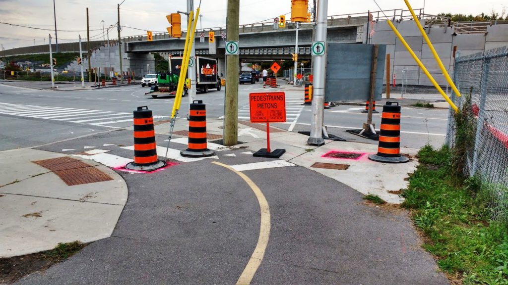
A big disappointment amid all of this was the reluctance of Stakeholder Relations staff to provide to Bike Ottawa the drawings of the intersection revisions without signing a non-disclosure agreement. For a public right-of-way, indeed! Fortunately, political intervention enabled our access to the plans without entering into an NDA. We provided feedback on the designs but were told that nothing could be changed within the scope of the LRT work; our recommendations might be considered by other City departments, but only after Stage 2 is completed there.
It is unacceptable for such an important biking corridor to be impeded for such a long time. Bike Ottawa will continue to seek proper accommodation of cycling during construction and to push for an earlier availability of the proper facilities.
Gladstone Avenue
If you have recently driven a car along Gladstone West of Preston St., or taken the number 14 OC Transpo bus, you might have noticed construction along the new LRT line 2 where the Corso Italia station is underway. You were able to get through the area without having to be forced to turn around. You most likely did not feel unsafe. You most likely weren’t even slowed down.
If you were walking, cycling or using a mobility device to get through the area, probably a very different experience. “Sidewalk Closed” signs appeared on the north sidewalk a number of weeks ago next to the Trillium MUP despite there being little to no construction activity observed in this space as of the end of May.
For years now, those using the Trillium MUP have had to play “Frogger” trying to dodge fast-moving car traffic to get across Gladstone as there is no crossing. This was not an oversight. City staff have no intention to install a crossing, or even until perhaps the new Corso Italia station is built.
Now everyone using that North sidewalk from Preston St. is forced to risk their lives trying to get across Gladstone and anyone using a bicycle is forced to “take the lane” increasing conflicts with impatient motorists. Anyone crossing Gladstone to continue on the Trillium pathway now has a partially obstructed view due to the pylon pile up, and approach to the crossing, making an already dangerous crossing worse. The dreaded “Single File” sign tells people on bicycles they will be forced into fast-moving car traffic while pedalling uphill. A scary situation for many such as families with children.
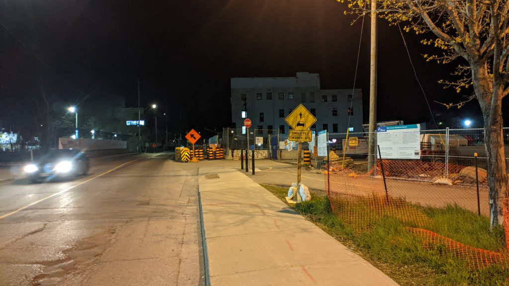
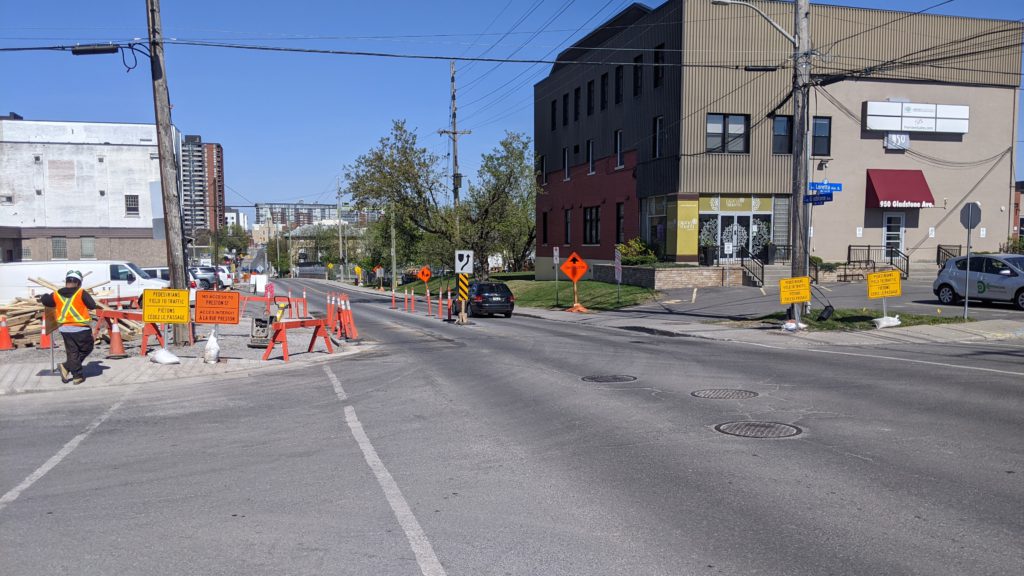
If coming in the other direction you are forced to cross Gladstone without any way to do so. Construction staff have even installed signs to advise pedestrians that they do not have the right of way at the very location where they are forced to cross because of the closed sidewalk.
This blockage also forces people outside of cars to risk their lives crossing midblock. This is the same location where someone on a bicycle was sent to the hospital last fall.
We continue to advocate for appropriate crossing and adequate safe space for people biking, walking, and rolling.
Lincoln Fields
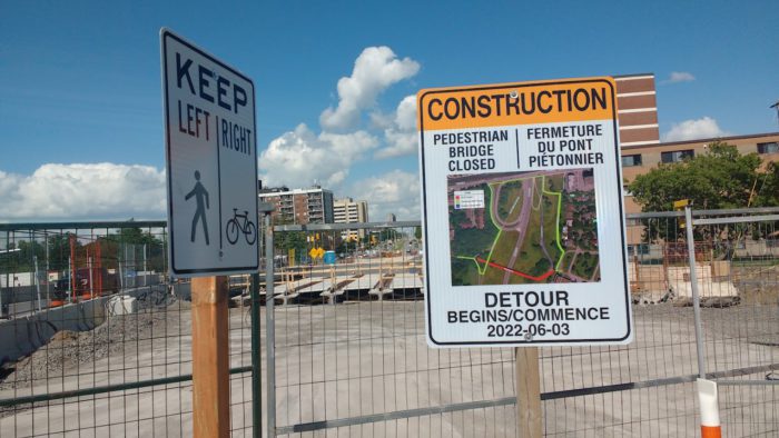
Lincoln Fields bridge, referred to by much of the community as the “Woodrooffe pedestrian bridge”, which crosses the transit way, provides (provided?) a safe accessible crossing for the community, including students accessing the high school on the east side. The detour is indefinite, as no one knows how long it will take for the new bridge to be put into place. The detour put in place is almost 1 km long. After push back from the community and many letters, we have received notice the detour is here to stay, although with some improvements from the original, including separated space for riding bikes.
From: Erinn Cunningham <erinn.cunningham@bikeottawa.ca>
Sent: May 10, 2022 9:54 PM
To: Tierney, Timothy <Tim.Tierney@ottawa.ca>
Cc: Bay Ward / Quartier Baie <bayward@ottawa.ca>; Leiper, Jeff <Jeff.Leiper@ottawa.ca>
Subject: #Ext Email# Proposed Detour For Woodroffe Pedestrian Bridge Replacement
Hi Tim,
As you may be aware, there is some concern being expressed about the detour being proposed due to the closure of the pedestrian bridge over the Transitway and Parkway near Woodroffe Avenue. In short, this is something that should not be happening, and the city should not be allowing it to be implemented.
Bike Ottawa’s first concern is that according to the LRT contract, any detour due to LRT construction isn’t allowed to be more than 20% longer than the original travel distance. The proposed detour will be roughly 3.5 times longer, adding unacceptable delays to people travelling this route.
Secondly, using the sidewalk to replace the existing MUP is also against the standards in the contract. While sharing might work for a small amount of time, the contract states a MUP should be replaced with a 3 meter wide MUP/paved surface, the sidewalk along Carling is neither.
We are concerned that this detour will detract from the safety of active transportation users, particularly in an area that is dominated by busy streets and the parkway. Circuitous detours have a tendency to encourage people to try and find quicker paths to where they need to go, and with plenty of high speed roads in the area, this is particularly troubling. Is this what students accessing the nearby high school, and local residents should expect when their city is supposed to be making it easier to move around the city without a private automobile?
Bike Ottawa asks that the city work with the LRT contractor to ensure that any detour put in place for this project is safe, as convenient as possible and abides by the terms of the contract.
Take care,
Érinn Cunningham
President, Bike Ottawa
From: Berlin, Damon <Damon.Berlin@ottawa.ca>
Date: Mon, May 30, 2022 at 3:18 PM
Subject: RE: #Ext Email# Proposed Detour For Woodroffe Pedestrian Bridge Replacement
Erinn,
Thank you for your email to Councillor Tierney, and for your patience while the City and KEV worked through the details of the detour to be implemented during the closure of the Woodroffe Pedestrian Bridge. This closure is now scheduled for Friday, June 3 at 7:00 a.m, and works to implement the detour’s features will take place over the next three nights.
Since first informing public of the detour, the City has worked at enhancing to ensure a safe and continuous segregated detour route for both pedestrians and cyclists. We selected the safest route possible for all users, and made efforts to ensure that they will be accommodated prior to the detour coming into effect. The route along Carling will be enhanced for active transportation users’ safety by segregating cyclists from both pedestrians and motor vehicles by closing the south-most eastbound lane with pin curbs and flex-post delineators, providing 3m width for bi-directional cycling, while pedestrians will remain on the sidewalk. Further, crossings of the ramps at SJAM will be improved for this detour by a) at the on-ramp from Carling, using a temporary speed hump to ensure slow vehicle speeds at the crossing point, which is already signed to provide right-of-way to those crossing the ramp, and b) at the off-ramp from SJAM, adding stop control. Below, I’ve added the detour map, annotated to identify that the enhancements.
Lastly, please note that we have worked closely with community advocates, as well as with Woodroffe High School, and have provided safety enhancements at all locations where concerns were expressed to us.
Again, thank you for your email and continued advocacy.
Damon
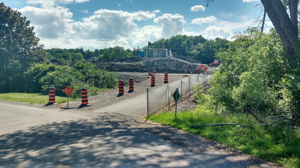
Our AWGer Paul Clarke went to investigate the detour (still not meeting the parameters of the LRT guidelines in full, but an improvement over the original), and reported back: There is now a bi-directional cycle track on Carling, although the west end of it is difficult to navigate when cross the ramps at the Ottawa River Parkway and making a tight turn to go down to the Pinecrest Creek Pathway. There is also a very rough granular section where the multi-use pathway detour goes under the new bridge. This does not meet LRT requirements for detours and needs to be changed to asphalt, as it is nearly impossible to bike or roll over them with wheels.
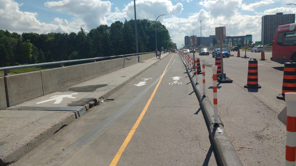
As for wayfinding, there is a small orange diamond sign to direct people for something, but the sign does not inform you of what (the bridge is closed). From this place, you cannot see that the old bridge has been removed due to a very large pile of dirt blocking the view and, as a result, those who don’t already know the bridge is gone will likely continue by and head toward the former gate in the fence that does have a sign. While we are glad to see there has been space for biking created here, the detour itself is still far too long and the lengthy section of rocks is unacceptable, as it is an impediment to user accessibility.
Regardless of all of the specifics of each detour, there is the ongoing issue that community members, councillors, and advocates should not have to spend countless hours working to have detours fixed, when there are clear guidelines that are meant to be getting this stuff fixed. It’s right there in the guidelines. Is this just another ‘culture shift’ that needs to happen? Creating safe detours should not be an afterthought, but a priority during construction.
Some will say “but the construction is necessary” and “we can’t stop progress”! True. But as Ontario is supposed to be heading to a fully accessible province by 2025, we need to ensure our most vulnerable do not face barriers and are kept safe even while construction activity is taking place in the right of way. So how do we do this? There are many options. And all these options should focus on one aspect: protecting vulnerable road users with safe detours.
Edited for clarity June 14, 2022 8:42 PM
Bike Ottawa has also learned since publishing this post, via the area Councillor, that the delay for the new bridge opening is due to a conflict with Hydro infrastructure near the end of the bridge – which was only discovered after the design was finished.

