Ride your bike to RBC Bluesfest and park it securely for free at Bike Ottawa’s #OttBikePark! This free bike parking is organised by Bike Ottawa.
We are the folks who advocate for better bike infrastructure, talk with politicians, pore over road designs and write the annual Report on Cycling in Ottawa. And organise events, such as your free bike parking.
Safe ride to RBC Royal Bank Bluesfest
North, east, south, or west… wherever you’re coming from there are safe and easy routes to ride your bike to RBC Royal Bank Bluesfest. The bike parking is located right off the multi-use path near the War Museum, and we have lots of signage and chalk markings on the paths nearby to guide you right to our location.
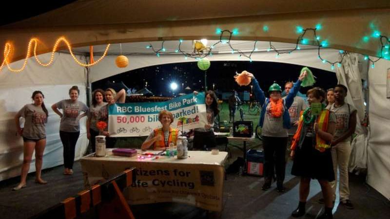
When you’ll get there, you’ll be able to get your bike parked for free at the Bike Ottawa supervised Bike Park compound, where volunteers have parked 50,000 bicycles over the last ten years. The Bike Park is located on the east side of Booth Street at the Ottawa River Pathway.
How does Bike Park work?
It works just like a coat check: we’ll get you to sign in, you give us your bike, we’ll give you a tag, and at the end of the night (or whenever you come back), you give us the tag and we give you the bike!
Make sure to hold onto your tag until the bike gets back, so that we make sure we get your bike to you!
How much does Bike Park cost?
Its free. Absolutely FREE! We want you to ride your bike to RBC Bluesfest, and we want to give you a safe place to park it while you’re there. In fact, not only is the Bike Park service free, we also have stuff to hand out or sell: NCC bike maps, bike lights (limited supply), cycling safety information, and more!
But if you like… we do collect donations, which go to Bike Ottawa and Bluesfest’s educational programmes: Blues in the Schools (BITS) and Be in the Band (BITB). The suggested donation is $2, and we’ll have a little gift to anyone who gives $5 or more…
But if you don’t leave a donation at all, that’s fine! We just want you to ride your bike, which is the most sustainable and convenient way to travel to Bluesfest. Everyone contributes to the community in their own way. We want you to have peace of mind that your bike is safe so you can enjoy the music!
Do I have to have a festival pass/ticket?
No, anybody can use the Bike Park, whether you’re a paying RBC Bluesfest customer, a volunteer, staff, or even if you’re not here for the festival at all but want to park your bike with us for the day!
Is there a long lineup at the end of the night?
We have refined our system over the past ten years and it is very efficient. There are four colours of tags: Just make sure you’re in the lineup for your colour and it won’t take long at all!
At the end of the night when it gets busier, there will be one volunteer for each lineup to assign a volunteer to get your bike. Be ready to show your tag to that person so they can send the volunteer.
Do I need to bring a lock? Or carry it with me?
No, it’s fully supervised and only Bike Park volunteers are allowed in the compound. They will park and retrieve your bike for you. You might want a lock if you’re going to stop somewhere else on the way home though 😉
This also means that you can leave your lock with your bike, as well as your helmet, saddlebags, lights, etc. too (no loose objects, please). You might want to take your water bottle with you, but don’t worry, our volunteers will usually ask you in case you forget!
How late are you open?
During the festival July 6-16, Bike Park is open 2:30pm-11:30pm on weekdays (closed Monday) and 10am-11:30pm on weekends. The music usually ends around 11pm, leaving time for you to claim your bike.
If you are an RBC Bluesfest volunteer on a shift that ends at or after 11:30pm, please inform the Bike Park volunteer and they will make arrangements so that your bike is taken care of.
How do I get to RBC Bluesfest by bike?
Note: most NCC pathways are not lit at night. You may want to consider alternate routes if you do not have a strong enough light on your bike.
From Centretown:
Take the Laurier Segregated Bike Lane to Bay Street, ride that all the way up to Wellington Street, and turn left. Click here for a map.
From there, if you take the road, turn left at the three-way intersection, then turn into the driveway for the Mill St. brewpub. The pathway connects at the bottom of the driveway and it leads straight to Bike Park!
If you want nothing to do with that intersection, continue and get onto the raised cycle lanealong the Portage bridge, then turn off it to the pathway that goes down the hill, then… do this.
OR,
stay on Laurier a little further (almost to its westernmost end) and use the new connector down Nanny Goat hill (near Percy), that will take you down to a stub of Wellington street and from there under the big 3-way intersection, kind of like this.
OR,
instead go up Bank Street past Parliament Hill, down the hill and parking lots to the pathway along the river. Click here for a map.
Tip: when the pathway splits (and turns, and goes into confusing directions), follow the solid yellow line to keep going west
From Little Italy/Hintonburg: Note that Booth Street is under construction.
Take the O-Train pathway all the way up to the Ottawa River, then turn right and continue along the river until you get to Booth. We’re right on the other side of the street! Note: the O-Train pathway is lit at night, but only up to the Transitway station. The Ottawa River Pathway is not lit.
From the north (Hull, Lac Leamy, Chelsea, Iqaluit…):
Follow the pathways to the Portage bridge, then take the raised pathway on the east side of the Portage Bridge and turn left onto the pathway before the intersection. Loop around and under the bridge, then pick up the pathway again near the Mill St brewpub’s driveway.
If you ride southbound on the Portage bridge in the general traffic lanes, turn right onto Wellington and then take the Mill St driveway to the pathway that leads straight to Bike Park
From the west (Westboro, Bayshore, Kanata, Renfrew, Vancouver…):
Take the Ottawa River Pathway and continue behind the museum to Booth Street. We’re just on the other side of Booth. Click here for a map.
From the east (Sandy Hill, Beacon Hill, Orleans, Rockland, Halifax…):
Follow your normal route to get to downtown, then you can take the Laurier Avenue Segregated Bicycle Lane and follow the directions for Centretown. Remember that the pathway behind Parliament is closed until 2018 due to flood damage, so avoid that route.
From the south (Glebe, Old Ottawa South, Alta Vista, Manotick, Miami…):
West of Ottawa River: Follow your normal route to get to Little Italy, then follow the Little Italy instructions
East of Ottawa River: Follow your normal route to get to the Glebe, then take Percy north under the 417. When the pathway ends, turn right and go one block to Bay Street, then continue north and follow the directions for Centretown.
Note that the pathway behind Parliament Hill is closed until 2018 due to flood damage, so you cannot take this route connecting from the Canal.
And if you aren’t planning to go at all, or take the car ($20), you can still donate to us:

