
Written by Hans Moor
Around 2018/2019, the City of Ottawa built a short stretch of multi use pathway (MUP) underneath the Beachburg Sub train overpass on Merivale Road to offer cyclists a safer alternative going north and south of the tracks. Until then, cyclists had to share the road with fast moving traffic, which was a very unpleasant experience to say the least. Today we are going to look if cyclists are using the multi use pathway.
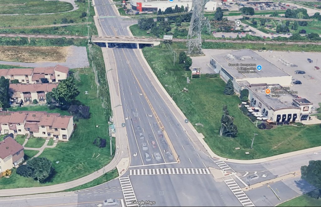
Merivale is four lanes wide here and has a 60 km/h limit. Downhill, when not stuck in traffic, drivers can be faster. The multi use pathway on Merivale connects bike paths south of the train tracks in Ward 9 with pathways along Nepean Creek and a route north of the tracks towards Baseline.
The route, called the Nepean Trail, runs roughly parallel east of Merivale Rd. It is a mix of residential roads, multi use pathways painted on-road bike lanes with, since summer 2026, flexiposts on Grant Carman.
The Nepean Trail route southbound crosses Viewmount, passes a car dealership and crosses Merivale at Colonnade towards the west end of Merivale Rd. After the Beachburg Sub train overpass, the route becomes an on road bike lane again on Woodfield Drive. It then continues towards the west end of Nepean to the Bruce Pit on several multi use pathways.
How popular is the MUP today?
We were interested in how popular the MUP along Merivale is. We decided to look at Strava Metro data. Strava is an internet service and mobile app used to track, analyze, and share physical exercises using GPS and connected fitness devices. They make aggregated running and cycling data available to cities and advocacy organisations. The data can not be traced back to individual users; the only thing we can see are totals on a certain stretch (called an ‘edge’ ) per month for the past 6 years.
Limitations
We have to bear in mind that using Strava data has limits, because:
- The pathway runs close to the southbound roadway, and we don’t know how precise Strava GPS pinpoints a cyclist;
- Strava users might generally be more confident cyclists who don’t object to road cycling;
- Strava data are slanted to enthusiastic cyclists and likely less used by a parent dropping off their child at school by cargo bike or a senior cycling to a grocery store;
- We don’t know the number of cyclists use Strava as a percentage of all cyclists, but we can guess, based on other data. We’ll attempt below.
Strava data currently doesn’t go further back than 2021. What happened before, we don’t know. Of course, Covid 19 and work from home in the years following Covid 19 may also have influenced the numbers. But despite those reservations, we can make an attempt to understand usage of the MUP. Having all this information in our pannier, let’s have a look at some numbers.
Strava Metro displays four lines on this stretch of Merivale Road. What we notice when looking at the data is that in 2021, there were 2570 Strava trips on the MUP, 175 trips southbound on the road and 170 trips northbound on the road. Interestingly, 505 Strava trips were counted on the northbound raised asphalt strip (called a ‘service strip’) and sidewalk. Because the service strip is very close to the road, these cyclists may also have cycled on the road. However, we will see later that there is a difference.
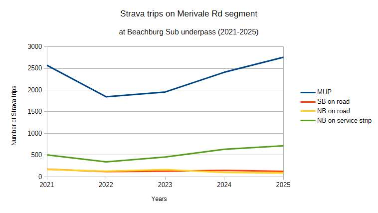
The following year, in 2022, there is a considerable dip down to 1845 trips, but in 2023 the numbers start climbing again.
Comparing with bike counters
“But wait”, you say, “that is just confident Strava users. What about the rest of us?” This is where we are going to look somewhere else first. We looked at some locations where the City of Ottawa has bike counters, that count every bike that passes the counters. Compared with Strava data at those locations where we DO know exactly how many people pass, the percentage of Strava riders vs. all riders counted on bike counters varies greatly, from around 25% of all trips being Strava trips on the William Commanda Bridge to less than 2% Strava trips of all trips on the Laurier bike lane eastbound.
That high number of Strava users on the Chief William Commanda bridge makes sense, as this leads directly to Gatineau Park where many performance cyclists train. The Laurier Ave bike lane serves a different type of cyclist, who is likely not starting Strava every time they bike to the bakery or the grocery store. So a low Strava count on Laurier also makes sense.
Commuter numbers were likely lower too on Laurier Ave in the COVID years, given many government employees who may have commuted to work previously worked from home for several years.
We know from comparing with city counts that on the Flora footbridge and the Adawe bridge around 6-8% is a Strava user. So let’s use 7% as an average for Strava users as a percentage of all cyclists on a certain stretch. We know it is a big, but somewhat justified assumption. It might be 6% or maybe 10%, but we need some ball park figure to work with.
Some observations
Looking on a map with Strava rides, It is worth noticing that the Woodfield – Merivale Rd MUP – Colonnade towards Nepean Creek and Grant Carman and v.v. is the prevailing route, not the Merivale – Hunt Club intersection. Given that Mario Theoret was killed in traffic by a driver in a large truck that turned into a south bound slip lane on that intersection without even noticing that they just run over someone, that doesn’t come as a surprise.
The total number of trips by Strava users increased from 3420 in 2021 to 3685 in 2025, but dipped in the years in between, likely due to Covid effects such as work from home. This would have affected the bike commuters.
The total number of Strava users at this segment of Merivale Road has gone down from 995 to 805. That doesn’t mean that less people cycle. In fact it could be more, but they may not use Strava anymore, or don’t share the data anymore.
If the number of Strava trips went up on Merivale Rd but the number of Strava users went down, it likely means that there is a core of Strava users who started to cycle this route more. Perhaps to exercise more, or perhaps going back to work more regularly? Or could it be that the retired population is increasing and is looking into cycling to stay fit?
The Merivale MUP is a popular choice
What we really wanted to know is how many trips are being made in total on the MUP along Merivale and if people chose the MUP over the road. If we use the above mentioned 7%, we will have to multiply the 2755 total Strava trips on the MUP in 2025 by (100/7%). Which makes 39,357 trips in 2025.
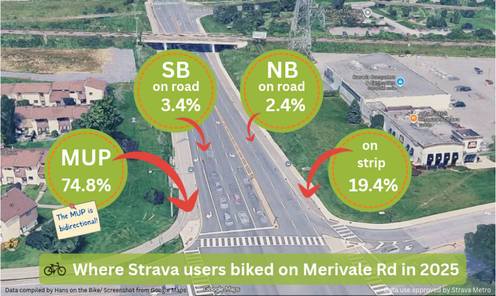
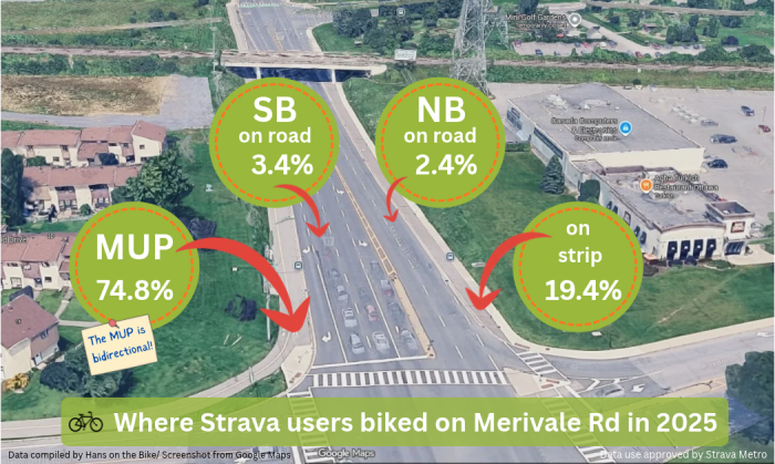
The percentage of Strava trips on the MUP as a total of all trips on that stretch of Merivale Rd was 75%. If we combine the Strava MUP trips with the service strip trips, then 95% of all Strava trips in this section are not in the four road lanes, but away from motorised traffic on the MUP and the service strip.
So yes, it is clear people prefer the Merivale MUP.
They sometimes say that cyclists are like water, they choose the shortest route (to save energy). There might be reasons why Strava users bike on the service strip northbound, rather than take the MUP on the other side of the road. They may come from the industrial area behind Costco (Roydon Pl), and do not want to cross Merivale Rd twice in 250 meters to get back to Colonnade Road. They may bypass backed up car traffic in rush hour and hop on the service strip.
Remember we mentioned above that there is a difference between the Metro data of the northbound road lanes and the northbound service strip? Interesting fun fact is that the average cycling speed in the northbound lanes on the road segment is considerable faster (over 30 km/h) than on the service strip northbound, which is closer to around 17 km/h.
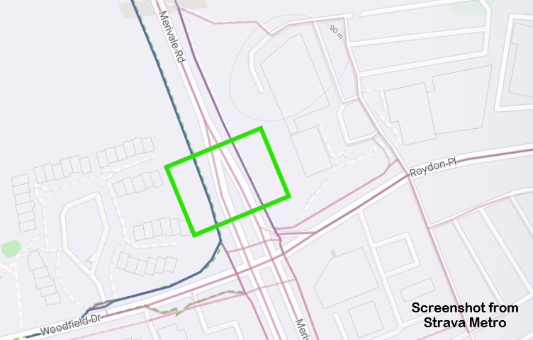
Above: the area we looked for data in the green square: left is the MUP (dark blue) then two pinkish lines (road cycling) and then on the right a darker line again, which is the service strip/sidewalk. The darker the line, the more Strava users.
Data source: Strava Metro (https://metro.strava.com), provided by Strava, Inc. Aggregated and anonymized pedestrian and bicycling trip data [2021-2025]. Graphs made in Libre Office Calc Screenshot map: Strava Metro