
This is the second post in our two part series related to the feedback we have provided about the new Ottawa Hospital plan. The following two documents are about the planned Infrastructure and Bike Parking.
If you missed the first post on Modal Shares and the Transportation Demand Management, you can find it HERE, and you can find our original overview of the site plan HERE.
In general, we feel that the infrastructure proposed in these designs is inadequate for non-car transportation, it prioritizes access to the campus by car, while more sustainable modes must continually work around car traffic when accessing the site. The plan does not incentivize active transportation and sustainable transportation. For some people, driving (or being driven) to the campus will make the most sense, but we see no real efforts to encourage those who could choose to use transit, walk/roll, or bike to the campus- staff particularly- to do so. This is reinforced by the design plan that favours easy access to campus via car, which, when prioritized, means sacrificing access, and even safety in some instances, of other people who choose not to arrive by car.
Parking is ample for those who drive, but those who walk, roll, take transit, or bike are asked to move the longest distances to the main buildings. In fact, their trajectory is interrupted and rendered much less safe by the on-campus car infrastructure.
Our feedback about bike parking on the new campus is centred around the suggestion that the new plan be re-thought to provide both secure long-term parking for employees, and short-term parking for those who have appointments or shorter visits. The former should be integrated into buildings and the latter at entrances, both must accommodate bikes of all types.
For a more detailed look at our concerns read on…
New Civic Hospital Campus Transportation Study: Infrastructure
This document concerns infrastructure at the new campus of the Ottawa Civic Hospital (TOH) as they arise in the Transportation Impact Assessment and Mobility Study (TIA).
Overall site configuration
In our letter of June 18, 2021, Bike Ottawa outlined several ways in which the current plans for the new Civic Hospital (TOH) campus prioritizes travel by automobile at the detriment of more efficient, sustainable modes of travel. In the portions of the present letter that address TOH’s modal-share projections and its Transportation Demand Management (TDM) plan, we observe how the TIA itself acknowledges that supporting these efficient, sustainable modes is vital to the hospital’s very function.
One of the most important ways to support more sustainable modes is to situate the hospital as close to the LRT station as possible—ideally, with the station integrated into the hospital, as with the transit connection at the Ottawa Hospital’s Riverside campus. In the proposed plan for the new Civic campus, however, the LRT station is the maximum distance from the hospital’s main entrance that the TDM contemplates: 600 metres (pp. 47, 66, and 68; Appendix S). This distance will function as a disincentive to accessing the hospital by transit.
An alternative scenario is where the main hospital building is located close to the street. The TIA’s TDM advises this very configuration: “Locate building close to the street, and do not locate parking areas between the street and building entrances,” “Locate building entrances in order to minimize walking distances to sidewalks and transit stops/stations”; and “reducing distances between public sidewalks and major building entrances” (Appendix S). The current site plan, however, ignores this advice. Likewise, the hospital’s main entrance is located at a considerable distance from Carling Ave, which is expected to be upgraded to include bus rapid transit (BRT) and dedicated biking facilities in the coming years (Appendix C).
Parking Garage
There are several significant problems with the parking garage as proposed in the TIA. To begin with, in its proposed location, it obstructs pedestrian traffic between the Dow’s Lake LRT Station and the hospital’s main entrance. The connection between the hospital and the LRT station is the most important one for employees and visitors. Indeed, the TIA itself acknowledges that “the integration of [Dow’s Lake] LRT Station to the future Civic Campus would highly improve pedestrian and cyclist safety by eliminating an at-grade crossing at Carling Avenue, a major arterial roadway” (p. 20). Despite this, it also admits that “there are currently no plans to integrate the [Dow’s Lake] LRT Station with the future hospital.”
Another significant problem is that the parking garage in its proposed location entails a removal of the portion of the Trillium MUP south of Carling Ave. We discuss this at greater length below.
The parking garage is also far too large. As other community groups have pointed out, its size is equivalent to the parking garage at the Ottawa airport, which, while itself obscenely large, is located in a location much more remote than that proposed for the new Civic campus. With its proximity to Dow’s Lake, among other features, the proposed garage’s location is prime real estate. At the very least, the garage should be installed underground, as was originally planned for the site, so that the valuable land on which it is situated may be preserved for more valuable uses than temporary automobile storage.
Finally, provisions should be made to make better use of car-parking spaces in this parking garage than temporary storage of private vehicles. For example, parking spaces should be convertible for more sustainable uses, such as bike parking, or even car-share services. While the TIA’s TDM mentions this possibility (Appendix S), it does so only cursorily; this should be an integral part of any plans for the parking garage.
Surface car-parking lots
Bike Ottawa is particularly concerned to see surface lots for private-vehicle storage in the TIA. The TIA shows 55 surface car-parking spaces at the main entrance (Parking Zone 2), as well as another lot with 238 spaces Parking Zone 4) (pp. 63–64). Car storage is widely acknowledged as one of the most inefficient, wasteful uses of urban space, and surface car parking is the most inefficient means of car storage. The only surface car infrastructure facilities justifiable on such prime land are roadways, drop-off zones, and facilities for emergency vehicles. Rather than wasting existing surface space on parking, the hospital should consider partnering with developers for projects coming onboard, such as the redevelopment of the Dow Honda site, to secure underground parking at these sites.
Overall quantity of car-parking
We are also concerned about the overall quantity of car parking in the TIA. Providing car infrastructure induces car dependency—the well-known phenomenon of “induced demand” (Jevon’s paradox). The TIA itself acknowledges that car dependency will need to be minimized for the hospital to function (p. 70). We understand that the TIA is to some extent constrained by the City of Ottawa’s car-parking bylaws, since its projected parking plan only exceeds minimums mandated by these by-laws by two spaces. To begin with, we urge that car parking at the new Civic campus be adapted to minimums established in the new Official Plan, when it becomes available. But we also reiterate our recommendation above—i.e., that these spaces be adapted to more sustainable uses. Finally, if it is car-parking minimums that prevent TOH from promoting more sustainable transportation options, we recommend that TOH apply for a variance with the City of Ottawa, as mentioned in the TDM (Appendix S, p. 8).
Trillium MUP south of Carling
Bike Ottawa objects to the elimination of the portion of the Trillium MUP south of Carling. The Trillium MUP is some of Ottawa’s best bike infrastructure, providing segregation from car traffic in a low-stress environment that cannot be matched by facilities adjacent to automotive traffic. The portion south of Carling connects the Trillium MUP to two popular destinations: Dow’s Lake and Prince of Wales Drive. As mentioned above, the location of the car-parking structure as proposed would entail the removal of this portion of the MUP.
While the TIA proposes rerouting this facility around the campus via Preston St. (pp. 55–56), this route takes people on bikes in close proximity to car traffic, introduces three new points of conflict with pedestrians (Carling and the Trillium MUP, Preston and Carling, and Preston and Prince of Wales), and is a longer and slower slower route to Prince of Wales. To be sure, there is already considerable volume from people on bikes and pedestrians on Preston, in particular, and for this reason the facility proposed here should stand—and it should be amply wide (a minimum of 5 m to accommodate the variety of non-standard bikes: tricycles, recumbents, cargo bikes, etc.) and with significant buffering from car traffic on the adjacent roadway to match the low-stress setting of the existing Trillium MUP south of Carling. Nevertheless, this can be no replacement for the portion of the Trillium MUP proposed for removal. Indeed, the TIA even acknowledges the value of the portion it proposes eliminating and the danger posed to people on bikes by Carling and Preston (pp. 17–18).
Prince of Wales
The TIA proposes maintaining bike facilities on Prince of Wales Dr, with an upgraded cycle track on part of the north side (and a bike lane the rest of the way) and a bike lane on the south side (pp. 56–57). While it is certainly welcome to have a portion of improved cycle track along this roadway, these facilities should be cycle tracks all along Prince of Wales from the intersection with Preston to the roundabout where it meets the Experimental Farm Driveway. This corridor is heavily used by people on bikes, particularly those commuting from the south end of the city, and so a safe, amply wide facility is necessary, particularly as the new Civic campus can be expected to generate increased traffic along this corridor.
Protected Intersections
We urge the implementation of protected intersections in two locations: the intersection of Carling Ave and Preston St and the intersection of Prince of Wales and Preston. As the TIA itself acknowledges, “Preston Street at Carling Avenue demonstrated higher risks for active transportation related collisions” (p. 17). Moreover, the City of Ottawa’s 2020 High-Volume Intersection Safety Review identified the intersection of Prince of Wales and Preston as a high-volume intersection that should be redesigned for improved safety (no. 24). We note that the Review specifically mentions “Potential coordination with future hospital development” (Document 3, p. 4). Now is clearly the time to implement this plan.
Sherwood bike facilities
In order to accommodate higher numbers of hospital staff, visitors and patients accessing the new Civic campus via sustainable modes of transportation, TOH should work with the City of Ottawa to prioritize the development of a bikeway along Sherwood Drive—a key bike route in the area, with connections to bike facilities across the west end and also a direct route to the hospital. Prioritizing active transportation along Sherwood will also help mitigate the potential for increased automobile traffic on this neighbourhood street.
On-campus facilities
The TIA also proposes paths through the campus in the current location of Queen Juliana Park. In the first draft of the TIA, the status of these facilities is unclear, however: they are marked “on-site pathway” and “secondary on-site path” (p. 56), with no indication of the mode for which they were intended—an additional indication of inadequate consideration of active transportation in the TIA. We were pleased, however, to see that in the revised TIA, the “on-site pathway” was changed to two facilities, a “bi-directional bikeway” and a sidewalk, which will segregate pedestrian traffic from bike traffic and continue the connection from Carling to Prince of Wales (revised TIA, p. 57).
We recommend that the facility currently labelled “secondary on-site pathway” be afforded the same segregated treatment. Many of the people on bikes coming from Sherwood and heading to Prince of Wales will no doubt prefer using the “secondary on-site pathway,” since it provides the most direct connection and is completely free from the dangers of automobile traffic. This is even more true for those who will access the main hospital entrance by bike from Sherwood, since this is a very direct connection. If left unsegregated, this “secondary on-site pathway” will undoubtedly see conflicts between pedestrians and people on bikes. (We are pleased to have received oral clarification from Graham Bird that all of the pathways mentioned in this section will include separate facilities for pedestrians and cyclists. Nevertheless, we believe this should be mentioned in official documents, with cross-sections provided for clarity.) In addition, the intersection of Roads A and B will need a cross-ride for those continuing through to Prince of Wales. This cross-ride should be both raised and stop-controlled, as this will afford those crossing extra protection from automobile traffic. We are concerned, however, that language about the intersection of Roads A and B being stop-controlled (p. 57) was removed in the revised TIA (revised TIA, p. 57), and we urge its reinstatement.
Bike Ottawa is also concerned about the roadways proposed in the TIA. The TIA proposes four car lanes for roads A1, A2, and B (Appendix N). By contrast, the TIA proposes mere 3 m facilities along these roadways for any other road users, whether people on bikes, pedestrians, or anyone else. This heavily car-oriented distribution is unfortunately characteristic of the TIA in general. Given the relatively small footprint of the new campus and the overwhelmingly local nature of traffic that will use the surrounding road system, we believe that the road network is overbuilt. Specifically, we believe that the roads should be no more than three lanes wide, with narrow lane widths and other features that limit traffic to 30km/h. At 30km/h, collisions between automobiles and people walking or people on bikes will not likely result in death or serious injury. Narrowing the roadway will be especially important at high-volume pedestrian crossings, such as at the intersection of Roads A and B: crossing a four-lane roadway is much more dangerous for pedestrians. Moreover, in light of the importance of these corridors and their proximity to the main entrance, facilities for people on bikes, pedestrians, and other users should be widened and segregated, and eliminating car lanes in these roadways would free up space for this.
Finally, we are concerned that TOH seeks to “limit direct access to the front entrance of the main Hospital building for cyclists” (revised TIA, p. 59). We find the provided rationale suggestive: “to reduce potential vehicle/cycling conflicts on Road A2.” This is another example of TOH prioritizing vehicle convenience over other modes. While we are pleased that TOH understands the threat that car traffic poses to people on bikes, among other road users, we believe that the solution to this is safer design, not seeking to remove access to non-vehicle modes. We also note that this solution fails to accommodate those for whom bikes are accessibility devices, and instead forces such people to find some alternative.
Level-of-service assessments
Bike Ottawa is concerned about Multi-Modal Level of Service (MMLOS) in the TIA. In brief, the TIA’s analysis clearly shows that in many places, the current plans do not meet standards for pedestrians, cyclists, or transit users:
- pedestrians:
- “No pedestrian PLoS targets were met” (p. 68)
- “No pedestrian PLoS targets were met” (p. 76)
- bikes:
- “Carling Avenue and Preston Street did not meet the BLoS desired target” (p. 67)
- transit:
- “the overall increase in traffic and delays causes most of the future intersections with transit routes to fall short of the TLoS desired target” (p. 77)
Despite falling short of targets for pedestrians and transit, the TIA in no place falls short of standards for personal vehicles or trucks. In fact, the TIA clearly states that one of the reasons standards of service for non-motorized vehicles are not met is the prioritization of vehicles.
- “The major factors preventing a PLoS of A include high vehicular volumes on all the segments and fast operating speeds” (p. 68)
- “The main factor causing poor PLoS includes how many lanes are required to be crossed…. Reducing the number of lanes of most of these intersections would result in extremely poor vehicular performance” (p. 76)
- “Carling Avenue and Preston Street did not meet the BLoS desired target due to lack of cycling facilities and high quantity of travel lanes on both roadways” (p. 67)
- “Carling Avenue did not meet the TLoS targets mainly due to congestion” (p. 67)
The TIA summarizes the situation as follows: “future MMLOS for road segments and intersections did not meet minimum targets for pedestrian and cyclist performance” (p. 87). In light of the TIA’s prioritization of automobile traffic over other modes of transportation, we are not surprised at this conclusion.
Pedestrian facilities
Bike Ottawa is concerned about the pedestrian walkway from the Dow’s Lake LRT station to the main hospital building (pp. 55–56). To begin with, the walkway’s value seems limited. Because it is elevated and thus disconnected from its surroundings, it can only serve as a corridor between two points: the LRT station and the hospital. The walkway entirely bypasses parts of the campus along the way, such as retail amenities along Carling or the proposed park atop the car-parking structure. As always, pedestrian infrastructure is in fact automobile infrastructure: it takes pedestrians “out of the way”—in this case, of an enormous car-parking structure. As mentioned above, a better solution would be a campus layout oriented toward sustainable transportation, where connections to transit, for example, are close and flexible. Instead, the proposed plan prioritizes cars and forces sustainable modes of transportation around car infrastructure. At the very least, a connection from the proposed walkway at the sidewalk along Road B should be provided for those who wish to access the walkway or garage-top park from Prince of Wales, or vice versa.
We are also concerned that the TIA makes no provisions for people who will use the LRT with a bike. Many people will bike from their home to a LRT station, take their bike on the LRT, and complete the trip to the hospital by bike—and vice versa for the return trip. Since this pathway is the main connection between Dow’s Lake Station and the main hospital entrance, and since the parking structure blocks the most direct route between these sites, people will undoubtedly bike along the pathway as well. We therefore urge that provisions be made on this pathway for people on bikes. Given the high traffic along this walkway, we suggest that the facility be wide and segregated.
We find other pedestrian facilities in the TIA inadequate. For example, we note that for most of the roadways, sidewalks are only provided on one side. The modesty of this provision is especially remarkable in comparison with TOH’s proposal of multiple lanes for car traffic on the same roadways (Appendix N). We also note that the TIA makes no mention of pedestrian crossings being raised. Raising these crossings is particularly critical along high-volume pedestrian routes, such as at the intersection of Roads A and B, or of Prince of Wales Drive and Road B. As mentioned above, we are also concerned that language about the intersection of Roads A and B being stop-controlled (p. 57) was removed in the revised TIA, and we urge its reinstatement. It is essential that pedestrians and people on bikes be afforded maximum protection at these crossings—particularly in light of the current plan for four car lanes on these roadways.
We note that there seems to be no direct pedestrian connection from the area of Prince of Wales and Road B to the hospital’s east arm or main entrance. Absent any such connection, we predict that pedestrians will forge their own path, some of which may come in conflict with car traffic. We recommend that these routes instead be anticipated and direct connections be provided. A proper connection along the south side of Road A2 to the main hospital entrance will be particularly important for those using the main car-parking structure, as this would eliminate a substantial number of crossings of Road A—and therefore also the potential for vehicle–pedestrian conflicts.
Finally, we note that despite substantial planning for the car-parking structure itself, the TIA provides almost no detail concerning how those using this structure will access the main hospital entrance; it merely states that “All proposed parking areas will be accessible by either sidewalk or pathway” (p. 55). We recommend that TOH give careful consideration to pedestrian traffic from all car-parking facilities on the campus.
Conclusion
Bike Ottawa thanks TOH in advance for its consideration of our feedback concerning infrastructure on the new Civic hospital campus. We invite TOH to contact us if it has any questions about our feedback. We would also be glad to work with TOH on these and any other measures and policies.
New Civic Hospital Campus Transportation Study: Bike parking
This document concerns bike parking at the new campus of the Ottawa Civic Hospital (TOH) as they arise in the Transportation Impact Assessment and Mobility Study (TIA). We devote a separate document to bike parking because bike parking is critical to making the campus bike-friendly: as the TIA’s own Transportation Demand Management plan (TDM) acknowledges, people will not bike to the campus if there is no place for them to store their bike securely (Appendix S).
Our main concern with bike parking in the TIA is the overall lack of information provided on the subject. This lack of information is particularly striking in comparison with the many pages the TIA devotes to car parking. We are concerned that this lack of detail constitutes further evidence that TOH has inadequately considered active transportation in its plans for the new Civic Hospital campus. In what follows, we outline a number of aspects that will need to be considered.
Total number of bike-parking spots
The TIA acknowledges that current City of Ottawa by-laws require a minimum of 630 bike-parking spots (p. 63). These minimums will soon be updated to reflect the City’s new Official Plan, however. Because this update will take place well in advance of the opening of the new Civic campus in 2028, and in order to conform to the City’s larger vision for transportation, Bike Ottawa believes that TOH should commit to adapting to the standards for bike parking set out in the new Official plan, once it becomes available. More than this, we believe that the TIA should include plans for increasing bike parking beyond those set out in its initial plans. As Ottawa’s transportation network gradually adapts to more sustainable forms of transportation, additional bike-parking capacity will be necessary.
Connectivity and locations
Bike parking should be distributed liberally around the new Civic campus to serve those working in or visiting every building. For bike parking that is underground or in other difficult-to-find locations, wayfinding should be provided from all main bike facilities. Because bikes are accessibility devices for some people, bike parking facilities for disabled people should be made available at the entrances of every building on the campus. At no point should those riding a bike be required to dismount prior to arriving at bike parking facilities. Sharp or narrow corners and steep grades should be avoided, as these limit facilities’ accessibility. Any doors that people must pass through with their bikes should be wide enough to accommodate non-standard bicycles, such as tricycles, and doors should be sensor-activated to alleviate the difficulty of opening doors and handling a loaded bike simultaneously. Bike parking facilities should never impact the Pedestrian Level of Service; these facilities should have their own dedicated space away from walkways and sidewalks.
We are pleased that the revised TIA provides evidence of having considered locations of bike parking (revised TIA, p. 68). We are concerned, however, about this plan. Above all, the majority of these locations are distant from the main hospital building. Apart from disincentivizing bike travel to the campus, we believe that people will attempt to bike to the main building anyhow and improvise bike parking, where necessary. It would be better to anticipate bike travel and provide proper facilities. We also are concerned that the map fails to distinguish between short-term and longer-term bike-parking facilities. The revised TIA seems to consider this distinction (p. 67), and this is an important distinction (see below); it should therefore be reflected in the map.
We are concerned that the revised TIA considers bike parking in the parking structure. We believe this is misguided. This location is distant from the various destinations on the campus, and thus people will seek out bike parking in those locations—and improvise, where necessary. Moreover, adding bike parking to the car-parking structure will only increase the size of an already oversized structure; nothing should be added to it that would contribute to this.
We also find the goal of situating bike parking in “proximity to Dow’s Lake Station” (revised TIA, p. 67) misguided. We expect that bike parking will already be provided at LRT station as part of the station design. We also believe that people who take their bike on the LRT will, when they arrive at Dow’s Lake Station, continue biking to their destination on campus. Priority should be placed on situating bike-parking facilities in proximity to destinations on the campus.
With regard to the specific locations of bike parking proposed in the revised TIA, we have several recommendations. For clarity, we have reproduced a copy of the map in the TIA (see below) with two modifications: 1) we have numbered locations, and 2) we have provided the locations proposed in the TIA in blue and our proposed locations in red.
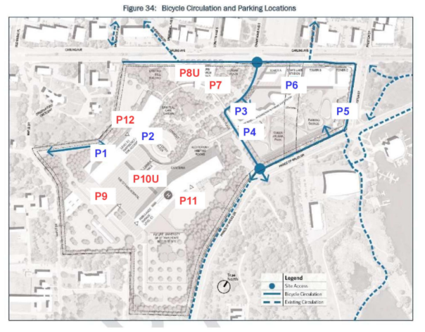
P1: Keep and provide wayfinding at Maple Dr and Road D.
P2: Keep and provide wayfinding signage at Roads A and B.
P3: Eliminate: too distant from destinations.
P4: Eliminate: too distant from destinations.
P5: Relocate in location connected to Towers B and C, and underground.
P6: Relocate in location connected proximity to Tower A.
P7: Provide facility at entrance to Research Building.
P8U: Provide facility underground in Research Building.
P9: Provide facility at back entrance of main building.
P10U: Provide large facility underground in main building.
P11: Provide facility on side of east arm of main building.
P12: Provide facility on side of west arm of main building.
Bike-parking equipment
Ample bike parking equipment should be provided that is accessible for all users, regardless of size or ability: for example, at least a portion of this equipment at every parking facility should be at ground level and should be roll-in, roll-out. Facilities should accommodate all types of bikes, including the various styles of cargo bikes, tricycles, and recumbents. Such facilities might include a combination of hydraulic wall-mounted racks, stacked parking, and floor parking for non-standard or heavy bikes. (By way of example, one popular model of cargo bike, the Babboe Carve, is 2.15 m long, 0.85 m wide, and 1.1 m high.) Several bike maintenance stands along with air pumps should be made available on the campus, as the TDM observes (Appendix S). In what follows, we provide recommendations for facilities in two sections distinguished by duration of use: short-term bike parking and day use (or longer).
Short-term facilities
Bike Ottawa suggests the provision of some bike-parking facilities oriented toward short-term visits to the campus, such as for people with appointments or making deliveries. The main priority for these facilities is speed of accessibility and proximity to building entrances. As such, most of these facilities should be located at ground level. Where these facilities are located outdoors, they should be sheltered from weather. These facilities may be a combination of ring-and-post design, which is most convenient but least secure, and pay-per-use lockers, which are less convenient but more secure.
Short-term facilities should be clearly visible, particularly to pedestrian traffic, as this improves their security. These facilities should also be protected from car traffic—at the very least, by a curb and by being distant from car facilities, especially roadways. Finally, provisions should be made for bike-share stations, as the TDM mentions (Appendix S). Most major Canadian cities have successful bike-share programs; while Ottawa does not currently, in March of 2021, City Council asked City staff to research the possibility of a future program.
Day-use (or longer) facilities
Bike Ottawa suggests the provision of bike parking facilities oriented toward day-use (or longer) visits to the new Civic campus, such as those for employees. In order to make biking more attractive for those spending longer periods of time on the campus, we recommend integrating secure bike parking facilities in all major buildings on the campus. With such facilities, security is a key consideration, since bikes will be left unattended for protracted durations, and bike theft quickly erodes confidence and thus disincentivizes biking. As such, onsite security staff will need to monitor such facilities 24 hours a day. Moreover, a substantial proportion of these facilities should be accessible only by fob, punch code, or some other security system. Finally, at no stage of using these facilities should anyone feel isolated or unsafe; facilities should be located in highly trafficked parts of buildings and well-lit.
Bike parking facilities should be connected to the remainder of the building in which they are located by easy-to-find stairs with large, adequate runnels, escalators, and elevators. Showers, change rooms, and locker rooms should be provided for employees, as the TDM acknowledges (Appendix S). These should be easily accessible from bike parking facilities and made available to all staff.
Winter-maintenance considerations
As the TOH’s location is situated on Ottawa’s winter cycling network, bike parking facilities should be designed to meet the standard of this network. Above-ground connections and ramps to any underground bike parking facility should be designed for year-round use and have excellent winter maintenance. Ideally, these facilities will be heated so as to remove all snow and ice immediately, since bikes are more precarious than other modes of transportation. If facilities are not heated, they will need to be designed in conjunction with the selection of winter-maintenance equipment, since this equipment poses special challenges to facilities (e.g., facilities need to accommodate the width of plows and brushes). A detailed plan for snow storage, drainage, and ice build-up should also be developed.
Bike Ottawa thanks TOH in advance for its consideration of our feedback concerning bike-parking facilities on the new Civic hospital campus. We invite TOH to contact us if it has any questions about our feedback. We would also be glad to work with TOH on these and any other measures and policies.